Early March Snow System Shows Medium Chance for Northern Kentucky, Lower Odds for Louisville and Lexington as March 1–3 Window Remains Highly Uncertain
KENTUCKY — A developing weather system could bring a round of snow to parts of Kentucky between March 1 and March 3, but forecasters stress that uncertainty remains high and confidence in exact impacts is still limited.
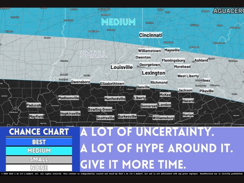
Current guidance suggests northern Kentucky — particularly areas closer to Cincinnati — has the best chance of seeing measurable snowfall if the system tracks favorably.
Northern Tier Holds the Better Setup
Forecast analysis shows a medium chance for snow across the northern tier of Kentucky, especially communities near the Ohio River and closer to Cincinnati.
Cities such as:
- Covington
- Maysville
- Williamstown
- Flemingsburg
appear to be in the zone with the highest current potential, depending on how the storm system evolves.
Forecasters note that track placement will be critical. A shift north or south could significantly alter snow placement and totals.
Central Kentucky: Possible, But Far From Certain
Central Kentucky, including Louisville and Lexington, currently sits in a small chance zone.
This means snow is possible, but confidence is low at this stage. Minor adjustments in temperature profiles or storm timing could determine whether precipitation falls as rain, a rain-snow mix, or accumulating snow.
Areas farther south — including Bowling Green, Somerset, London and the southern half of the state — currently show even lower odds of seeing snow during this window.
Why the Forecast Is So Uncertain
Meteorologists emphasize several key variables still in play:
- Storm track
- Temperature profiles at the surface and aloft
- Timing of precipitation onset
- Model consistency
Long-range model runs have shown inconsistency, with some simulations increasing snowfall potential while others scale it back.
This type of volatility is common in early March setups, when seasonal temperature swings can complicate precipitation type forecasts.
No Need for Panic — Yet
Forecasters are urging residents not to overreact to early hype surrounding the system.
Yes, snow is possible in early March.
No, exact totals are not known.
And no, it is not time to cancel plans.
Confidence typically improves within three to five days of an event, when short-range models provide more reliable data.
What Happens Next
Over the coming days, meteorologists will refine projections as new data becomes available.
For now, the takeaway is clear:
- Northern Kentucky currently holds the better chance.
- Central Kentucky remains uncertain.
- Southern Kentucky appears less likely to see snow.
As March begins, winter may not be finished just yet — but whether it makes a noticeable return will depend entirely on how this system behaves.
Are you in northern Kentucky and watching this closely? Let us know what you’re seeing in your area and stay updated with continuing weather coverage at SaludaStandard-Sentinel.com.