Destructive Warning Issued for McPherson and Marion Counties Kansas as 101.8 MPH Winds and Quarter Size Hail Slam Galva Canton and Surrounding Communities
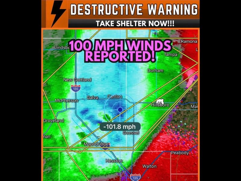
McPHERSON, KS — A destructive severe thunderstorm warning was issued for McPherson and Marion counties in central Kansas after radar velocity data confirmed wind gusts reaching 101.8 mph near Galva and Canton, with quarter-size hail also reported as the catastrophic storm complex tore through rural communities demanding immediate shelter from all residents in the affected zone.
Radar Confirms Catastrophic Wind Speeds
Velocity data captured by radar and displayed by LiveStormChasers.com showed a measured inbound velocity of negative 101.8 mph near Goessel — a reading that places this event firmly in the category of destructive, infrastructure-threatening wind damage. Negative velocity values of this magnitude on base velocity scans confirm winds of that speed directed toward the radar site, indicating the true wind field within the storm core was producing catastrophic straight-line wind gusts across the affected corridor.
Wind gusts exceeding 100 mph are capable of destroying mobile homes, collapsing weakly constructed buildings, snapping mature trees at the trunk, and downing power infrastructure across multiple counties simultaneously.
Communities Under the Destructive Warning
The warning polygon encompassed McPherson, Galva, Canton, Goessel, Moundridge, Hesston, and rural portions of both McPherson and Marion counties. New Gottland, Groveland, and communities along the Highway 135 corridor also fell within the warning boundary, leaving a broad swath of central Kansas facing simultaneous threats from catastrophic winds and significant hail.
Quarter-size hail accompanying winds of this speed creates an additional hazard, as hailstones driven horizontally at 100 mph carry enough force to shatter windows, damage vehicles, and injure anyone caught outdoors without protection.
The Broader Storm Context
This destructive warning event was part of the larger life-threatening storm complex moving southeast across Kansas Monday night, the same system that was tracking toward Wichita with embedded tornadoes and 100 mph winds reported across multiple counties simultaneously. Central Kansas bore the initial brunt of the complex before it continued its southeast progression toward more densely populated areas.
Immediate Safety Reminder
Any resident within a destructive warning polygon must treat the situation as immediately life-threatening. Move to an interior room on the lowest floor of the strongest available structure and stay away from all windows and exterior walls until the warning expires.
For continuing coverage of destructive storm events and severe weather across Kansas and the United States, visit SaludaStandard-Sentinel.com.