Dense Freezing Fog Threat Expands Across Michigan’s Lower and Upper Peninsulas Sunday Morning, Visibility Could Drop Below Half Mile
MICHIGAN — Dense fog is expected to develop again early Sunday morning, February 15, 2026, marking the third straight day of reduced visibility across parts of the state, with some areas potentially seeing visibility fall to less than half a mile.
Calm surface conditions and ongoing evaporation are helping fuel the persistent fog pattern, especially across central and northeastern sections of the Lower Peninsula, the Keweenaw Peninsula, and portions of the central Upper Peninsula.
Freezing Fog Risk Increases as Temperatures Fall Into the 20s
Overnight temperatures are forecast to drop into the 20s, raising the likelihood that fog will become freezing fog in several locations. That shift brings added concern for slick patches forming on untreated roads, bridges, and elevated surfaces.
The threat appears especially elevated north of Mount Pleasant, where lingering surface moisture combined with sub-freezing air could lead to icy conditions early Sunday morning.
Visibility May Drop Below Half a Mile in Multiple Communities
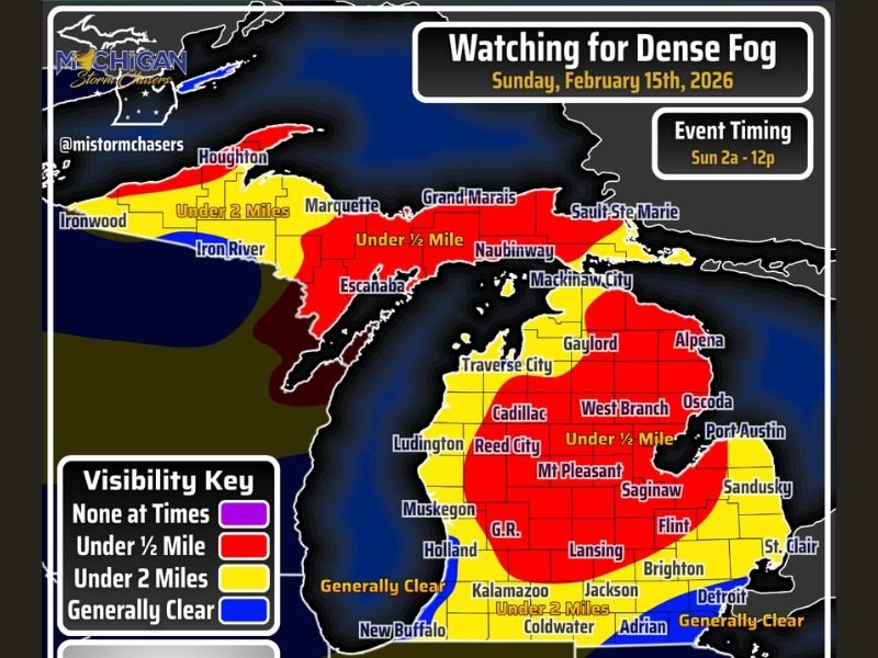
Regional storm tracking graphics show red-shaded zones where visibility could dip below one-half mile between roughly 2 a.m. and noon Sunday. Yellow-shaded regions may see visibility reduced to under two miles, while southeastern Michigan is expected to remain generally clear.
Communities including Marquette, Escanaba, Naubinway, Cadillac, Reed City, Mount Pleasant, West Branch, and Alpena fall within the higher-risk visibility areas. Meanwhile, Detroit and surrounding southeastern communities are forecast to see fewer impacts.
Forecasters stress that fog coverage will likely be patchy, meaning not every location inside the highlighted zones will experience persistent dense fog throughout the entire morning.
Travel and Safety Concerns for Early Sunday Drivers
Officials advise drivers to activate both headlights and taillights when traveling through fog. Reduced visibility combined with freezing temperatures can create sudden and dangerous conditions, particularly in rural or low-lying areas. Motorists are urged to allow extra travel time and remain alert for rapid changes in visibility levels.
Northern Lights Viewing Could Be Limited Overnight
The fog may also interfere with overnight opportunities to view the northern lights. Dense fog and reduced visibility at times could make skywatching difficult across impacted areas.
Conditions are expected to gradually improve by around midday Sunday as clearing begins to take hold. Residents noticing significant fog or icy road conditions are encouraged to share their experiences with SaludaStandard-Sentinel.com and help keep communities informed.