December Cold Blast Set to Send Temperatures Plummeting Across Texas, Oklahoma, and the South as Arctic Air Surges In
TEXAS — The first major Arctic blast of December is gearing up to hit the South and Central U.S. with force, dropping temperatures to as much as 35 degrees below normal across Texas, Oklahoma, Arkansas, Louisiana, Mississippi, and Kansas, according to new model data.
Meteorologists say this is not a minor cold spell — it’s a massive winter plunge that could make the first week of December feel more like mid-January.
December Starts With a Deep Freeze
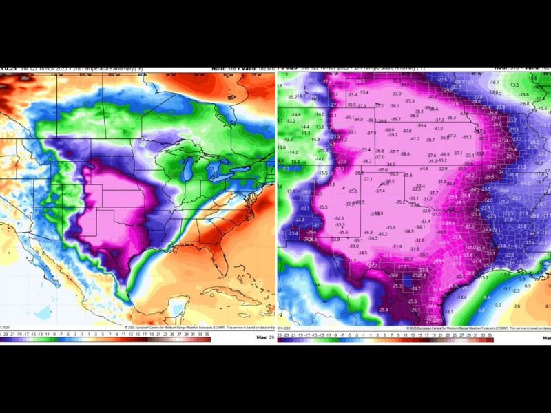
Forecast models, including the European Centre for Medium-Range Weather Forecasts (ECMWF), show an intense cold surge developing across the central U.S. around December 1, with temperatures in some areas 30–40 degrees below average.
“This isn’t a temperature anomaly,” one forecaster joked online. “This is Mother Nature kicking the thermostat so hard it filed an OSHA complaint.”
The viral commentary highlights just how extreme this cold outbreak could be — with Texas and Oklahoma seeing temperature drops that may rival some of the coldest early-December readings on record.
Cold Air Spreads Across Multiple States
The Arctic air mass will sweep southward through the Plains and Lower Mississippi Valley, enveloping much of the region in deep blue and purple shades on the latest temperature anomaly maps.
- Texas could see temperatures as low as 35°F below normal, with the strongest chill settling over the Panhandle and Central regions.
- Oklahoma, Arkansas, and Kansas are also expected to feel the brunt of the polar plunge, where wind chills could drop into the teens.
- Louisiana and Mississippi, states accustomed to mild winters, may also see their coldest air of the season, with some areas struggling to climb out of the 40s.
Meanwhile, Florida appears to be one of the few regions spared from the deep freeze — for now. Models show the Sunshine State staying relatively warm, prompting jokes online that “Florida’s over there glowing orange like a pumpkin spice latte, pretending it’s not winter.”
A Polar Vortex Signature
Meteorologists say this kind of sharp temperature contrast — from freezing conditions in Texas to balmy weather in Florida — is a classic sign of a Polar Vortex intrusion. Cold air from the Arctic is being funneled southward by a strong jet stream dip, setting the stage for one of the most dramatic early-season cold snaps in recent years.
The EURO model shows widespread pink and purple shades blanketing the southern U.S., indicating the core of the coldest air, while forecasters caution that wind chills and frost hazards could pose risks for livestock, travel, and outdoor activities.
Residents Advised to Prepare Early
Officials are urging residents across affected states to prepare for freezing conditions, check on vulnerable neighbors, and ensure pets and outdoor plants are protected. With such extreme temperature swings expected, energy demand may also spike as households switch from late-autumn warmth to sudden winter cold.
Experts say Texans in particular should brace for rapid weather changes — from sunshine and highs in the 70s to below-freezing mornings within 48 hours.
An Early Start to Winter’s Grip
As December 1 approaches, forecasters agree: this Arctic front means business. While long-range models still differ slightly on duration, most suggest the cold pattern could persist well into the first half of December.
“This isn’t just a cool-down — it’s a full-on temperature nosedive,” one meteorologist said. “For many parts of the South, winter is arriving early and with attitude.”
Residents are encouraged to stay tuned for local forecasts as the cold air moves in and to prepare for possible frost, ice, or even snow in parts of the Plains.
To share how the cold front is impacting your area, visit SaludaStandard-Sentinel.com and join the discussion.