Dangerous Tornado Warning Issued for Pensacola and Baldwin Counties: Take Cover Immediately
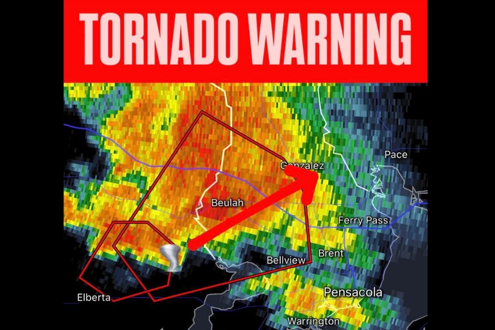
PENSACOLA, FLORIDA — The National Weather Service (NWS) in Mobile has issued a tornado warning for central Escambia County in northwestern Florida and southeastern Baldwin County in southwestern Alabama. The warning remains in effect until 11:45 p.m. CDT Saturday night.
Meteorologist Chris Nunley confirmed that as of 11:10 p.m. CDT, radar detected a severe thunderstorm capable of producing a tornado approximately five miles northwest of Lillian, or 11 miles northeast of Foley, moving northeast at 20 mph.
Radar Indicates Rotation — Tornado Possible
The NWS reported radar-indicated rotation, suggesting a developing tornado within the storm system. Officials warned that flying debris could be deadly for anyone caught outside or without shelter.
“Mobile homes will be damaged or destroyed. Damage to roofs, windows, and vehicles will occur. Tree damage is likely,” the NWS alert stated.
The impacted region includes rural communities in southeastern Baldwin County and central Escambia County, including Beulah, Gonzalez, and Brent, located north of Pensacola.
Residents Urged to Take Cover Immediately
Authorities are urging all residents within the warning area to seek shelter immediately. The NWS advises moving to a basement or an interior room on the lowest floor of a sturdy building, avoiding windows at all costs.
“If you are outdoors, in a mobile home, or in a vehicle, move to the closest substantial shelter and protect yourself from flying debris,” the warning emphasized.
Those living in mobile homes or temporary housing are considered at high risk, as even brief tornado touchdowns can cause catastrophic damage.
Storm Track and Hazards
The storm system continues moving northeast, tracking across the Beulah and Gonzalez areas, with potential impacts expected near Ferry Pass and northern Pensacola if the storm holds its strength.
Along with the tornado threat, hail up to 0.75 inches in diameter and winds over 60 mph have been observed.
Local meteorologists are closely monitoring the storm’s rotation signature, and further warnings could be issued as conditions evolve.
Safety Recommendations
Residents are urged to:
- Stay tuned to local radio, television, or NOAA Weather Radio for updates.
- Keep flashlights, cell phones, and emergency supplies ready.
- Avoid driving or being outdoors until the warning expires.
As of now, there have been no confirmed tornado touchdowns, but the risk remains high as atmospheric conditions continue to favor severe weather development across the western Florida Panhandle and southern Alabama.
Stay with SaludaStandard-Sentinel.com for continuous weather updates and emergency information.
Author: Savannah Greene | Category: Weather