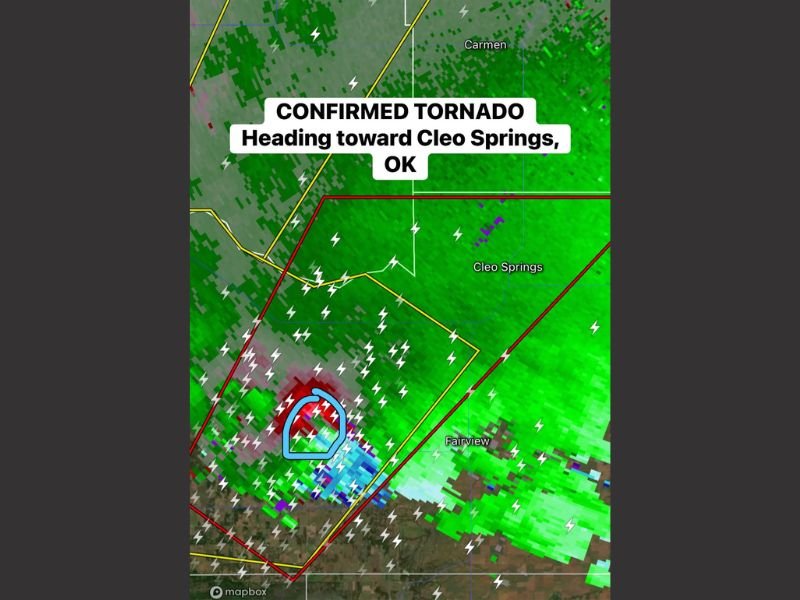
Confirmed Tornado Racing Toward Cleo Springs, Oklahoma as Violent Storm Cell Triggers Emergency Radar Signatures
OKLAHOMA — Meteorologists confirmed a tornado developing within a powerful storm cell moving toward the community of Cleo Springs as severe weather intensified across northwestern Oklahoma. Radar imagery showed a classic tornadic signature as the storm strengthened near the Fairview area before tracking northeast toward Cleo Springs.
Weather radar indicated strong rotation embedded inside a severe thunderstorm, prompting urgent warnings for residents in the path of the storm. Lightning activity surged throughout the system while the radar velocity scan showed opposing wind motions — a key indicator of a tornado either on the ground or forming rapidly within the storm.
The storm was moving through a region already under severe weather alerts, increasing concerns that the tornado could cause significant damage if it reached populated areas.
Radar Shows Strong Rotation South of Cleo Springs
Meteorologists analyzing the radar data identified a concentrated area of rotation just southwest of Cleo Springs. The velocity scan highlighted intense inbound and outbound wind speeds packed closely together, which is often considered one of the strongest radar signatures associated with tornado formation.
The storm was initially detected near the Fairview area before strengthening as it moved northeast. As the rotation tightened, weather trackers flagged the storm as a confirmed tornado threat moving directly toward Cleo Springs.
Lightning markers scattered throughout the storm showed that the thunderstorm was extremely active, another sign of strong atmospheric instability fueling the severe weather outbreak.
Storm chasers and radar analysts monitoring the system warned that the storm had the potential to rapidly intensify due to favorable atmospheric conditions across northwestern Oklahoma.
Severe Thunderstorm Warning Expanded Across Northwestern Oklahoma
The tornado-producing storm developed within a broader severe thunderstorm system spreading across the region. Weather alerts were issued as the storm cell intensified, with warnings covering areas around Cleo Springs and nearby communities.
These warnings indicated the possibility of destructive winds, large hail, and tornado formation as the storm progressed. Radar reflectivity images showed heavy precipitation cores along with the rotating storm structure.
Communities in the path of the storm were urged to move to safe locations immediately as the system continued advancing.
Emergency officials emphasized that storms capable of producing confirmed tornadoes can change direction or strengthen quickly, making early sheltering essential.
Communities Urged to Take Shelter Immediately
As the storm approached Cleo Springs, residents across northwestern Oklahoma were advised to take immediate safety precautions. Tornado warnings indicate that a tornado is either occurring or imminent based on radar detection or visual confirmation.
Residents were urged to move to basements or interior rooms away from windows and remain alert for additional warnings as the storm progressed through the area.
Weather experts warned that storms producing confirmed tornado signatures often remain dangerous for extended periods, particularly during large severe weather outbreaks.
Officials continued monitoring radar closely to determine whether the tornado would intensify or shift direction as it moved across rural portions of the state.
Severe Weather Season Increasing Across the Plains
The tornado near Cleo Springs developed as part of a larger severe weather pattern affecting parts of the central United States. Spring months typically bring an increase in severe thunderstorms across the Plains, where warm, moist air from the Gulf of Mexico collides with colder air masses moving south from Canada.
These atmospheric clashes create ideal conditions for rotating supercell thunderstorms capable of producing tornadoes.
Meteorologists say rapid storm development during these setups can lead to sudden tornado warnings with little lead time, highlighting the importance of weather alerts and real-time radar monitoring.
Residents across Oklahoma and surrounding states were encouraged to stay alert as additional storms were expected to develop throughout the evening.
If you experienced severe weather in your area or have storm photos to share, join the conversation and tell us what you’re seeing. Stay connected with the latest updates by visiting SaludaStandard-Sentinel.com as severe weather continues to unfold across the United States.