Colorado, Wyoming and Nebraska See Widespread Rain and Mountain Snow as Moisture Returns and Pattern Shift Toward El Niño Begins
COLORADO — A broad area of precipitation is spreading across parts of Colorado, Wyoming, and Nebraska, bringing much-needed moisture to regions that have been waiting for relief.
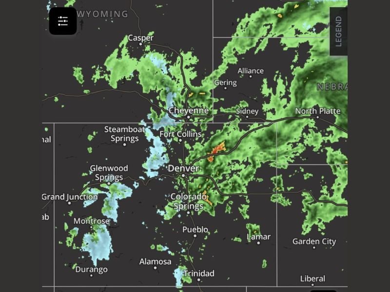
Radar imagery shows rain falling across cities including Denver, Colorado Springs, and Fort Collins, while higher elevations and western areas are seeing snow, particularly near Steamboat Springs, Glenwood Springs, and mountainous terrain.
Widespread Precipitation Bringing Relief Across the Region
The current system is delivering a mix of rain and snow across multiple states, with steady precipitation extending north into Wyoming, including areas near Cheyenne and Casper, and eastward into western Nebraska.
This moisture is especially significant for drought-prone areas, where even modest rainfall can help improve soil conditions and water supply levels. Observations confirm that precipitation is reaching both urban and rural regions, increasing its overall impact.
Rain in Lower Elevations, Snow in the Mountains
The system is producing a classic spring pattern across the Rockies and High Plains. Lower elevations, including Denver and surrounding metro areas, are seeing mostly rain, while colder air at higher elevations is allowing snowfall to develop.
Snow bands are visible west of Denver and across central and western Colorado, with additional snow pockets extending into parts of southern Wyoming. This combination helps boost mountain snowpack, which is critical for long-term water resources.
Localized Storm Activity Embedded Within Rain Bands
In addition to steady rain, radar indicates pockets of heavier precipitation, particularly south of Denver near Colorado Springs and Pueblo. These areas could experience brief bursts of heavier rain or isolated thunderstorm activity.
While severe weather is not the primary concern in this setup, localized heavier cells may produce gusty winds and short-duration downpours.
Greeley and Northern Colorado Also Seeing Benefits
Reports confirm rainfall reaching areas like Greeley and northern Colorado, highlighting the widespread nature of this system. Even lighter precipitation in these areas contributes to improving dry ground conditions after extended dry stretches.
The coverage across the Front Range and adjacent plains suggests this is not an isolated event, but rather a region-wide moisture event.
Signs of a Larger Weather Pattern Shift Emerging
Looking ahead, forecasters note that this system could be part of a broader transition in the overall weather pattern. There are increasing indications that the atmosphere may be shifting away from La Niña conditions and moving toward a more El Niño-influenced setup.
Such a transition often brings more frequent storm systems and increased precipitation chances, particularly across parts of the western and central United States.
More Opportunities for Rain Expected Next Week
Early outlooks suggest that next week could continue this trend, with additional chances for precipitation across Colorado, Wyoming, and Nebraska. While exact timing and intensity remain uncertain, the pattern appears more active than recent weeks.
This could mark the beginning of a more sustained period of moisture, which would be beneficial for agriculture, water storage, and overall drought recovery.
Residents across the region are encouraged to stay updated as forecasts evolve and additional systems develop. Share your local conditions and stay connected with ongoing coverage at SaludaStandard-Sentinel.com.