Colorado Thunderstorm Hits North Denver Metro With 55 MPH Wind Gusts Threatening Flight Disruptions at Denver International Airport
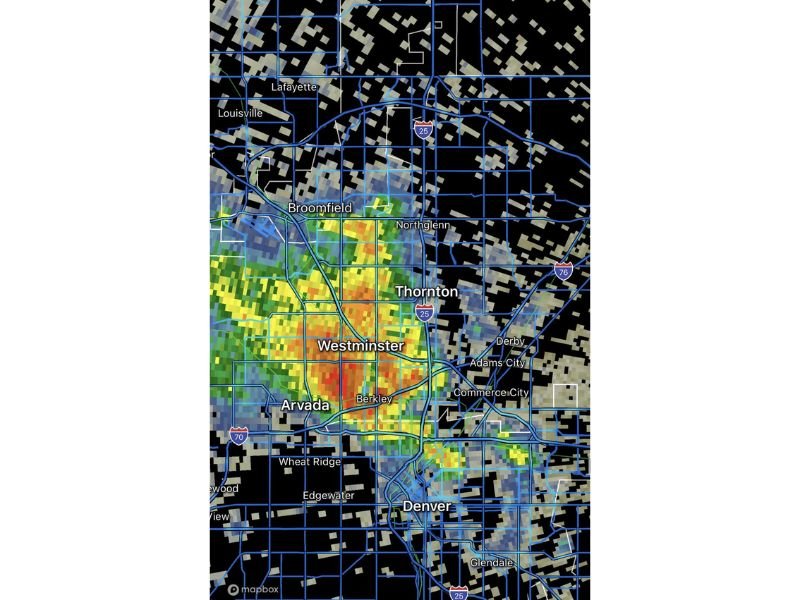
COLORADO — A thunderstorm is currently impacting the north Denver metropolitan area, bringing heavy rainfall and wind gusts of up to 55 MPH that are threatening to cause disruptions at Denver International Airport. The storm was reported at 6:12 PM and is producing the heaviest precipitation across a corridor covering Westminster, Thornton, Arvada, Broomfield, and Berkley, with radar showing intense returns concentrated directly over the western and central portions of the north Denver metro.
Heavy Storm Core Centered Over Westminster and Arvada
Radar imagery shows the most intense precipitation cores of the thunderstorm concentrated directly over Westminster and Arvada, with significant rainfall returns also covering Thornton, Berkley, Broomfield, and Northglenn. The storm is producing a dense and tightly packed area of very heavy rainfall across this corridor, with the brightest radar returns indicating the strongest downpours located in the Westminster and Arvada zone.
Communities including Commerce City, Adams City, Derby, Wheat Ridge, and Edgewater are also experiencing storm impacts as the system pushes through the broader north Denver metro area during the early evening hours.
55 MPH Wind Gusts Could Disrupt Denver International Airport
One of the most significant concerns with this thunderstorm is the potential for wind gusts reaching up to 55 MPH in the vicinity of Denver International Airport. Wind gusts at this intensity are capable of causing ground stops, ground delays, and disruptions to arriving and departing flights at one of the nation’s busiest airports.
Travelers with flights scheduled through Denver International Airport during the evening hours are strongly advised to check their flight status directly with their airline before heading to the airport. Delays and gate changes are possible as ground crews manage operations during periods of strong gusty winds and active lightning in the area.
Road Conditions Impacted Across the North Metro Corridor
Beyond the airport disruption risk, the thunderstorm is also creating hazardous driving conditions across the north Denver metro road network. Heavy rainfall falling rapidly onto urban roadways can lead to standing water, reduced visibility, and slick surfaces particularly along major corridors including Interstate 25, Interstate 70, and Interstate 76 which all run through the heart of the storm impact zone.
Drivers across Westminster, Thornton, Arvada, and surrounding communities are urged to reduce speeds, increase following distance, and avoid any roadways where water is observed pooling or flowing across the travel lanes during the storm passage.
Lightning remains an additional hazard for anyone outdoors across the affected area, and residents are advised to move indoors immediately and remain inside until the storm clears the region completely. Are you experiencing the storm in the Denver metro area? Share your reports at SaludaStandard-Sentinel.com.