Colorado Faces Extreme Wind Event: 102 MPH Gusts Recorded Near Denver as Powerful System Sweeps the Front Range
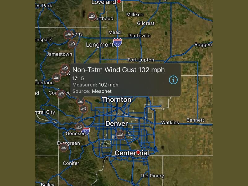
DENVER, CO — A powerful windstorm blasted the Denver metro area and surrounding Front Range communities this week, with gusts topping 102 miles per hour, according to meteorological data from the Colorado Mesonet. The extreme event, which occurred west of Denver, has been described as one of the strongest non-thunderstorm wind episodes in recent years for the region.
The 102 mph gust was recorded around 5:15 p.m. local time near the foothills west of the city, as part of a widespread synoptic wind event fueled by a tight pressure gradient and downslope flow off the Rocky Mountains.
Hurricane-Force Gusts Sweep the Front Range
Meteorologists say the winds were caused by a powerful mountain wave pattern, a phenomenon where fast-moving air descends from higher elevations and accelerates as it approaches the plains.
This setup often triggers intense localized gusts capable of reaching hurricane strength — even outside of thunderstorms.
The latest data shows several 90–100 mph wind readings stretching from Boulder and Lyons to Golden and Evergreen, with the Denver metro area also experiencing sustained winds of 50–70 mph throughout the day.
“When you’re seeing over 100 mph gusts without a thunderstorm, that’s a serious atmospheric setup,” said a National Weather Service meteorologist in Boulder. “We had near-record pressure gradients combined with strong upper-level jet support.”
Damage and Power Outages Reported
The extreme winds led to power outages, downed trees, and travel delays across multiple counties.
Local utilities reported scattered service interruptions due to fallen power lines, particularly in Jefferson, Boulder, and Arapahoe counties.
High-profile vehicles, including semi-trucks and delivery vans, were advised to avoid I-70 and U.S. 36, where crosswinds were strong enough to cause rollovers.
Residents in foothill areas like Golden, Genesee, and Evergreen shared images of flying debris and toppled fences.
“It sounded like a freight train hitting the neighborhood,” said one Evergreen resident. “I’ve lived here 20 years and have never heard wind howl like that.”
Rare but Not Unprecedented
While winds exceeding 100 mph are rare outside mountain passes, Colorado’s Front Range corridor is no stranger to destructive gust events.
Meteorologists compare this storm to past “Chinook wind” incidents, where strong downslope air masses brought hurricane-strength gusts to populated areas.
Thursday’s system was part of a larger-scale pressure shift affecting much of the western United States, contributing to widespread gusts from Montana to New Mexico.
Safety Reminders and Precautions
Officials urged residents to stay alert for falling debris and to secure outdoor furniture, Christmas decorations, and trash bins ahead of future gusty periods.
The National Weather Service warns that similar wind setups could return later in the winter season as jet stream patterns remain active.
Forecasters say calmer conditions are expected to return to Colorado by the weekend, but emphasize that localized high winds could continue in mountain passes and exposed ridge lines. Stay updated on regional weather alerts, forecasts, and emergency advisories at SaludaStandard-Sentinel.com.