Colorado and Wyoming See Expanding Showers Ahead of Wednesday Storm System With Denver and Cheyenne in Early Impact Zone
COLORADO, WYOMING — A broad area of showers is already spreading across parts of Colorado and southern Wyoming, signaling the early stages of a larger storm system expected to move through the region on Wednesday.
Showers Expanding Across Colorado and Southern Wyoming
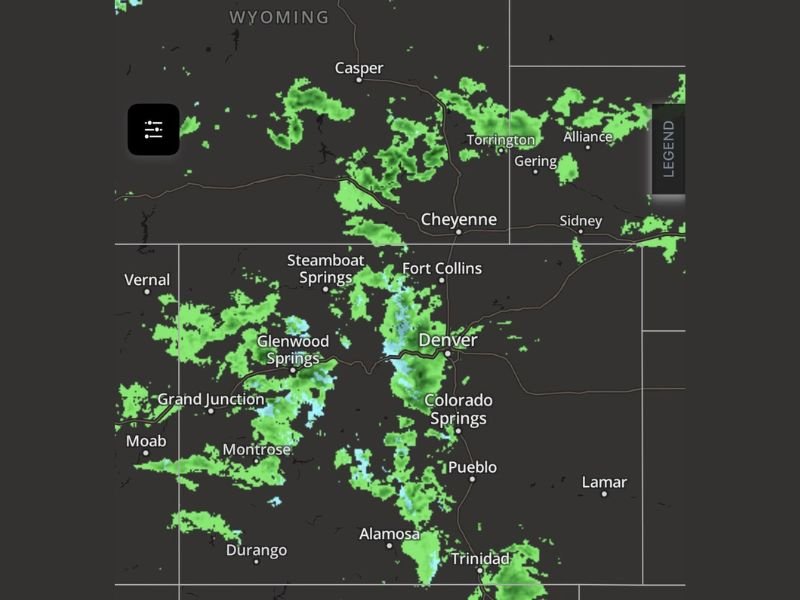
Radar imagery shows scattered to numerous showers developing from western Colorado through central areas and extending north into southern Wyoming. Cities including Denver, Fort Collins, and Cheyenne are already seeing increasing precipitation coverage.
While rainfall remains mostly light to moderate at this stage, the growing coverage indicates a strengthening system approaching from the west.
Mountain Areas Seeing Steadier Precipitation
Higher elevations across western and central Colorado, including areas near Steamboat Springs, Glenwood Springs, and Montrose, are experiencing more consistent precipitation.
These areas are often the first to see impacts as moisture pushes inland, and conditions there suggest the system is continuing to organize as it advances eastward.
Denver Corridor Begins to Feel Early Impacts
The Denver metro area is beginning to see pockets of rain, with showers becoming more widespread through the evening hours. This marks the transition phase before the main system arrives.
Communities along the Front Range, including Colorado Springs and areas south toward Pueblo, are also seeing developing precipitation.
Main Storm System Arrives Wednesday
These showers are just the precursor to a more organized storm system expected on Wednesday. As the system moves fully into the region, precipitation is expected to increase in both intensity and coverage. The setup suggests a more active weather day ahead, with broader impacts likely across both Colorado and Wyoming.
Travel and Visibility May Be Affected
Even with lighter rainfall, expanding showers can reduce visibility and create slick road conditions, particularly during evening and overnight hours. Drivers across affected areas should remain cautious as conditions gradually deteriorate ahead of the main system.
What Comes Next
As the system continues to develop, conditions across Colorado and Wyoming are expected to shift from scattered showers to more widespread precipitation on Wednesday. Residents are encouraged to stay updated as forecasts evolve and additional details about timing and intensity become clearer.
Seeing showers in your area or preparing for Wednesday’s system? Share your updates and stay informed with full coverage at SaludaStandard-Sentinel.com.