Cold Front Sweeps Wyoming Colorado and Nebraska Bringing Snow in Mountains and Powerful 60 MPH Wind Gusts Across Plains
WYOMING, COLORADO, NEBRASKA — A sharp cold front is pushing through the central Rockies and High Plains, bringing a burst of colder air, mountain snow, and dangerously strong winds across parts of Wyoming, Colorado, and western Nebraska.
The system is already moving along the I-80 corridor and expanding into surrounding regions, signaling a dramatic shift in conditions heading into Friday.
Cold Air Drops Temperatures Into the 30s Behind the Front
Behind the advancing cold front, temperatures are falling quickly, with many areas dropping into the 30s. This colder air is helping transition precipitation from rain into wet snow, particularly across higher elevations and colder zones.
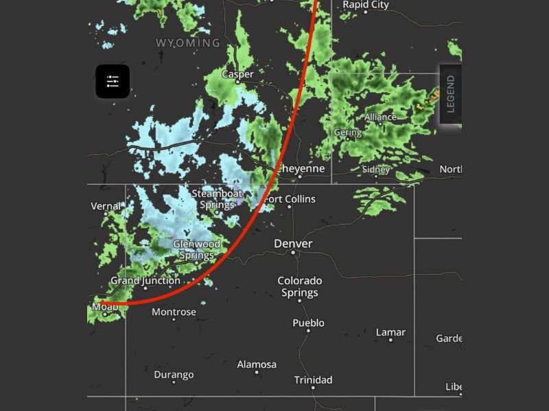
The most notable snow activity is expected in the mountains, southern Wyoming, and parts of northern Colorado, especially along the Cheyenne Ridge extending into western Nebraska.
Snow Mainly Confined to Mountains and Northern Zones
While the system carries moisture, most of the meaningful precipitation will remain limited to mountainous areas and nearby higher terrain.
Locations such as southern Wyoming and extreme northern Colorado are seeing the best chances for accumulating snow, while western Nebraska may experience lighter mixed precipitation. Lower elevation areas along the Colorado Front Range may see only brief showers, with minimal overall accumulation due to downslope effects.
Powerful Winds Become the Biggest Threat
The most impactful part of this system is not the snow—but the wind. As the front pushes through, strong north to northwest winds are expected to intensify, with sustained speeds between 15 and 25 mph and gusts reaching as high as 40 to 60 mph.
These winds could create hazardous travel conditions, especially for high-profile vehicles along open highways, including stretches of I-80 and surrounding routes. Blowing snow in higher elevations may also reduce visibility at times.
Blustery and Uncomfortable Conditions Expected Friday
Friday is shaping up to be a cold, windy, and uncomfortable day across the region. Even where temperatures manage to reach into the 50s at lower elevations, strong wind gusts—potentially up to 55 mph—will make it feel significantly colder.
Higher elevations will remain much colder, with lingering snow showers and persistent wind keeping conditions raw throughout the day.
Limited Moisture but High Impact From Wind
Despite the presence of precipitation, overall moisture totals are expected to remain relatively low. Downsloping winds will limit widespread rainfall or snowfall in many lower elevation areas, meaning the system’s primary impact will come from wind rather than heavy precipitation. This combination of limited moisture and strong winds creates a classic High Plains scenario—dry but powerful.
Travel and Outdoor Plans May Be Affected
Those with travel or outdoor plans should be prepared for rapidly changing conditions, especially with strong crosswinds and colder temperatures.
Mountain travel routes could see slick spots from snow, while open plains may experience sudden wind gusts capable of making driving difficult. Residents are encouraged to secure loose outdoor items and remain cautious through the frontal passage.
If you’re experiencing strong winds or changing weather conditions in Wyoming, Colorado, or Nebraska, share your updates and stay informed with the latest coverage on SaludaStandard-Sentinel.com.