Clipper System Expected to Produce Blizzard-Like Conditions, Ice, and 45–55 MPH Wind Gusts Across Minnesota and Iowa From Tuesday Afternoon Into Wednesday Morning
MINNESOTA & IOWA — A fast-moving but messy clipper system is expected to impact Minnesota and Iowa from Tuesday afternoon through Wednesday morning, bringing a mix of rain, snow, ice, and the potential for blizzard-like conditions in some areas. Forecasters warn that strong wind gusts between 45–55 mph could create hazardous travel conditions even where snowfall amounts remain light.
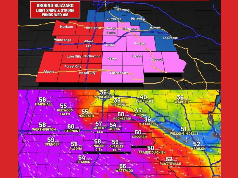
Wind Gusts Up to 55 MPH Could Create Ground Blizzard Conditions Along and West of I-35
Meteorologists report that locations along and west of I-35 may experience the most severe conditions, where light snowfall combined with powerful winds could lead to:
- Ground blizzard conditions
- Rapid drops in visibility
- Snow blowing across roadways, creating slick and unpredictable surfaces
Future wind gust forecasts highlight widespread values between 45 and 60 mph across southern Minnesota and northern Iowa, including:
- Rochester: near 50 mph
- Mankato and Albert Lea: 55–57 mph
- Austin & Mason City: 54–59 mph
- Worthington: up to 58 mph
These wind speeds may cause drifting snow, power line issues, and difficult driving overnight Tuesday into early Wednesday.
Snowfall Expected to Remain Light, but Travel Disruptions Likely
Although this system is not expected to deliver heavy accumulation, areas along and east of Highway 52 may still pick up a couple of inches of new snow. Even small totals could become hazardous when combined with strong winds and bursts of snow.
Forecasters emphasize that slick roads, icy spots, and blowing snow will remain the primary hazards rather than total snow depth.
Clipper Brings Mix of Rain, Snow, and Ice Across the Region
The storm’s precipitation type will vary based on location, with some areas seeing:
- Rain transitioning to snow
- Intermittent freezing drizzle or ice
- Wind-driven snow squalls
This messy precipitation mix increases the risk of rapidly changing roadway conditions, especially during the late-night and early-morning hours.
Travelers Urged to Monitor Forecasts Closely
Officials are advising residents and travelers across Minnesota and Iowa to prepare for:
- Hazardous late-night travel
- Strong crosswinds on highways
- Reduced visibility from blowing snow
- Potential brief power outages
Those planning to travel overnight Tuesday through Wednesday morning are encouraged to check updated advisories and allow extra travel time.
How will these strong winds and blizzard-like conditions affect your week? Share your thoughts with us at SaludaStandard-Sentinel.com.