Climate Prediction Center’s January 2026 Outlook Shows Above-Average Temperatures Across the Southern United States as Winter Pattern Shifts
UNITED STATES — The Climate Prediction Center (CPC) has released its updated January 2026 winter outlook, showing a strong likelihood of above-average temperatures across the Southern United States, while parts of the Northern Plains and Upper Midwest lean colder. The forecast also highlights mixed precipitation trends and ongoing uncertainty connected to Arctic sea ice loss and polar vortex behavior.
Key Takeaways From the January 2026 Outlook
To make the main information clear, here are the most important points from the CPC update:
- Above-average temperatures expected across Texas, Louisiana, Mississippi, Alabama, Georgia, and Florida
- Colder-than-normal conditions likely for portions of the Northern Rockies and North-Central U.S.
- Equal chances for near-normal temperatures in parts of the Midwest, Mid-Atlantic, and Northeast
- Rainfall expected to be average to below average across several regions
- Potential Arctic outbreaks still possible, especially after the New Year
- Polar vortex disruptions remain a concern due to melting Arctic sea ice
- Seasonal outlooks suggest continued warmth through February and March in the South
- CPC warns that budget cuts and sea ice program funding loss may impact long-term Arctic tracking
Southern U.S. Poised for a Warm January
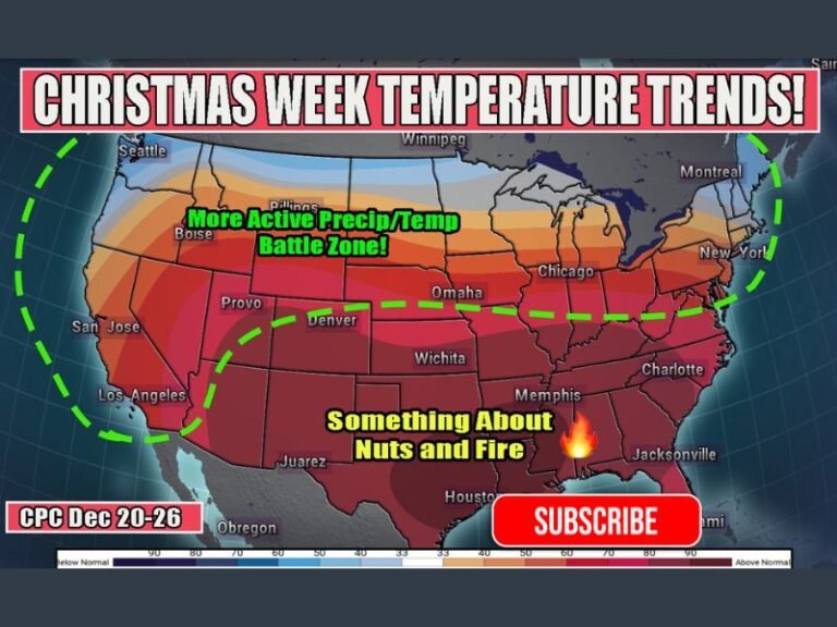
The CPC’s temperature probability map shows a broad swath of warmer-than-normal conditions extending from New Mexico through Texas and across the Deep South into the Carolinas and Florida. This pattern suggests milder winter conditions for millions of residents, with fewer opportunities for sustained cold spells early in the month.
However, meteorologists caution that individual Arctic outbreaks could still occur, particularly after January 1st. These cold shots may arrive around the second week of the month but are not expected to dominate the overall pattern.
Northern Tier Braces for Colder Signals
While the South warms, portions of the Northern Rockies, Dakotas, and northern Great Lakes show increased chances for below-average temperatures. This aligns with early-season trends indicating more active cold fronts and stronger snowpack influence in high-latitude regions.
Equal-chance zones across the central and eastern U.S. reflect areas where neither cold nor warmth shows a clear statistical advantage.
Precipitation Outlook Shows Mixed Signals
For January 2026, CPC precipitation guidance indicates:
- Average to below-average rainfall across the Southern Plains and Deep South
- Above-average precipitation possible in the Ohio Valley and parts of the Upper Midwest
- Equal chances of wet or dry conditions in much of the central U.S.
Seasonal (Jan–Mar) projections show continued warmth in the southern states and a tilt toward wetter-than-usual conditions for parts of the Midwest and Great Lakes.
Forecast Uncertainty Tied to Arctic Changes
Meteorologists note that melting Arctic sea ice continues to disrupt traditional polar vortex behavior. With monitoring programs facing cuts, long-range prediction may become more challenging. Analysts stress patience as new data becomes available closer to January.
Are you noticing winter temperature shifts in your region, or preparing for a warm January? Share your observations and stay updated at SaludaStandard-Sentinel.com.