Christmas Forecast Split: Major Model Disagreement Creates Uncertainty for Holiday Temperatures Across South Carolina, Georgia, Alabama, Mississippi, and Florida
SOUTH CAROLINA — A highly unusual and sharp disagreement between major weather models has cast uncertainty over Christmas Day temperatures across the Southeast, with projections ranging from Arctic cold to unseasonably mild conditions. Meteorologists say the split between the GFS and EURO models is significant enough to leave South Carolina and neighboring states unsure whether Christmas morning will bring winter chill or spring-like warmth.
GFS Model Suggests a Cold, Potentially Arctic Christmas Morning
The GFS model continues to push a strong surge of cold air into the Southeast, projecting much lower temperatures on December 25. Under this scenario, states including South Carolina, Georgia, Alabama, Mississippi, and northern Florida could wake up to:
• Widespread 30s and low 40s
• A sharply colder air mass moving in from the north
• Conditions more typical of early January than Christmas Day
This model indicates a colder and more traditional winter feel, suggesting that families across the region may need coats, layers, and heating systems ready for holiday gatherings.
EURO Model Shows a Much Milder, Spring-Like Christmas Pattern
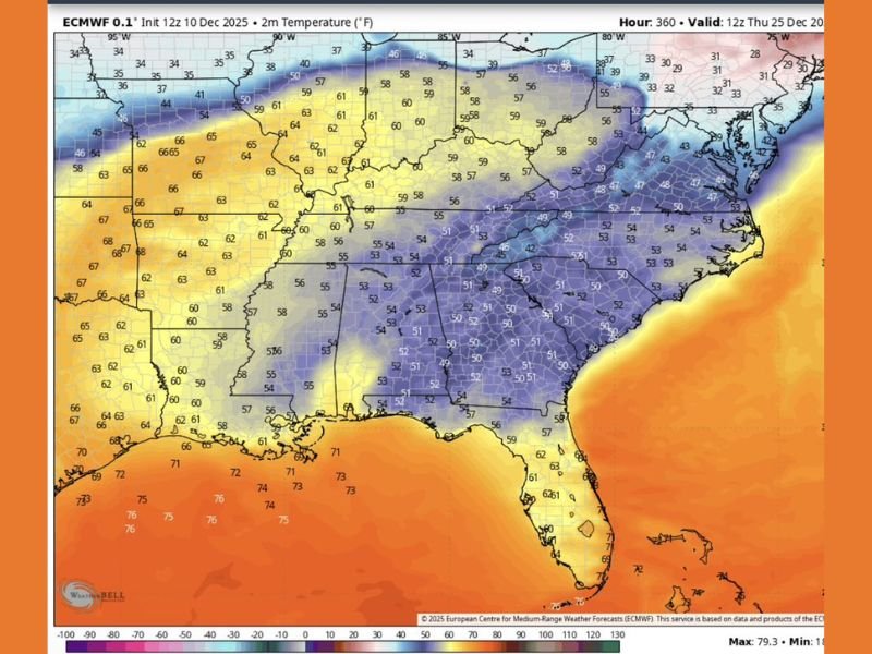
In stark contrast, the EURO model projects much warmer temperatures, with Christmas morning readings across the Southeast in the 50s and even low 60s. This pattern would resemble a late-autumn or early-spring setup, far from the cold scenario suggested by the GFS.
Forecast maps show:
• South Carolina: temperatures in the upper 40s to low 50s
• Georgia and Alabama: widespread 50s
• Mississippi: upper 50s to low 60s
• Florida: 60s and 70s, with warmth pushing northward
If this model verifies, it would deliver a mild and comfortable holiday, with outdoor activities far more feasible.
Why the Models Disagree So Sharply
Meteorologists note that the disagreement stems from each model handling the incoming upper-level pattern differently. The GFS pushes Arctic air deeper into the South, while the EURO keeps the cold air bottled farther north and allows warmer Gulf air to dominate.
When models diverge this dramatically within the seasonal transition period, forecasters urge caution and emphasize that final outcomes may not be clear until closer to the holiday.
Residents Should Prepare for Wide Possibilities
Given the current model split, residents across the Southeast should be prepared for either scenario:
• A colder, winter-like Christmas with Arctic air in place
• A much milder Christmas with temperatures running 10–20 degrees above normal
Meteorologists stress that such large differences this close to the holiday are uncommon, underscoring the unpredictable nature of the season’s weather patterns.
More Clarity Expected in the Coming Days
Forecasters expect updated model runs over the next few days to help narrow down which scenario is more likely as Christmas approaches. Until then, families planning travel or outdoor holiday events should monitor forecasts closely.
For updated Christmas forecasts across South Carolina and the Southeast, visit SaludaStandard-Sentinel.com.