Carolinas Face Potential Blizzard Conditions as Bomb Cyclone Threat Prompts Winter Storm Warnings
NORTH CAROLINA & SOUTH CAROLINA — Winter Storm Warnings and Watches are now in effect across a large portion of both North Carolina and South Carolina as forecasters track a rapidly intensifying coastal storm that could evolve into a powerful bomb cyclone just offshore by Friday evening.
Meteorologists warn that the system may strengthen quickly enough to support blizzard conditions, particularly across eastern North Carolina and the Outer Banks, where an upgrade to a Blizzard Warning is being discussed if confidence continues to increase.
What Is Driving This Storm Setup
The developing system is expected to undergo bombogenesis, a process that occurs when a storm’s central pressure drops by at least 24 millibars within 24 hours. This rapid intensification is similar in structure and impact to the rapid strengthening seen in hurricanes, though the hazards in this case would be snow, wind, and coastal impacts.
Model guidance shows the low-pressure center forming offshore and strengthening aggressively as it moves northward, tightening the pressure gradient along the Carolina coastline.
Snowfall and Blizzard Potential Across the Carolinas
Latest blended snowfall guidance indicates a significant snow band stretching across eastern and central portions of North Carolina, with heavier totals focused closer to the coast. Some inland areas of South Carolina may also see accumulating snow depending on the final track.
If the storm intensifies as projected, strong winds combined with heavy snowfall could meet official blizzard criteria, particularly along the Outer Banks and adjacent coastal counties.
Wind, Coastal, and Travel Impacts
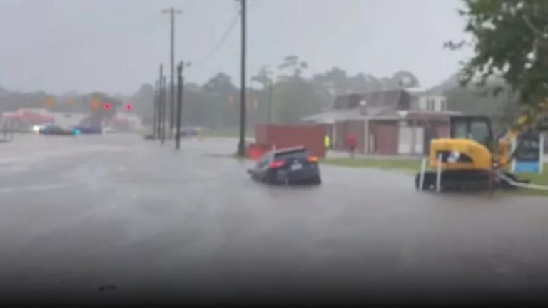
In addition to snow, forecasters are closely monitoring the potential for dangerous wind gusts, which could lead to near-whiteout conditions, power disruptions, and hazardous travel. Coastal regions may also experience significant marine and beach impacts, including rough surf and localized flooding as the storm strengthens offshore.
Could Snow Reach as Far South as Florida?
Some guidance suggests that snow flurries could extend unusually far south, with the possibility — though highly uncertain — of flakes reaching parts of Tampa, Florida. While accumulation is not expected that far south, the signal highlights just how cold and expansive this air mass may become.
What Residents Should Do Now
With winter storm alerts already posted and the storm still organizing, residents across the Carolinas should begin preparing for rapidly changing conditions, particularly from Friday through Sunday.
Travel plans may need to be adjusted, and those in coastal or eastern areas should stay alert for possible upgrades to Blizzard Warnings as confidence improves. Stay with SaludaStandard-Sentinel.com for continued updates, forecast refinements, and local impact details as this potentially high-impact winter storm develops.