Carolinas and Georgia Face Rare Dual-Threat Winter Storm as Freezing Rain, Thundersleet, and Tornado Risk Collide Sunday Afternoon
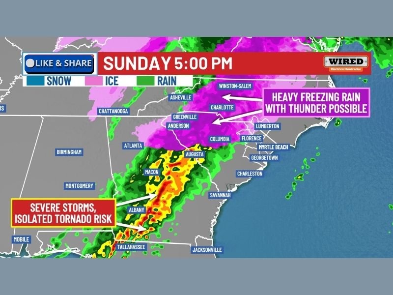
SOUTH CAROLINA — A volatile and dangerous winter storm is unfolding across the Southeast, placing North Carolina, South Carolina, and Georgia at the center of an unusually complex weather setup Sunday afternoon and evening. Meteorologists warn this system brings simultaneous ice storm conditions in some areas and severe thunderstorm threats in others, a rare overlap that significantly increases the risk to life, property, and travel.
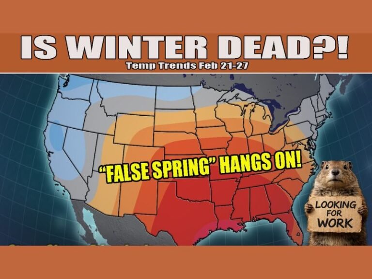
The worst conditions are expected as the storm intensifies later Sunday, with impacts stretching from the Carolinas into Georgia and parts of Alabama.
Dangerous Freezing Rain and Thundersleet Across the Carolinas
In central and northern South Carolina and North Carolina, the primary threat is heavy freezing rain and sleet, with surface temperatures remaining below freezing while warmer air rides in aloft. This setup allows liquid rain to freeze on contact, rapidly coating roads, trees, and power lines with ice.
Forecasters warn that thunder and lightning may occur during freezing rain, a phenomenon known as thundersleet, which signals intense upward motion within the storm. Cities including Greenville, Anderson, Columbia, Charlotte, Winston-Salem, and surrounding communities are especially vulnerable to dangerous icing. Ice accumulation could become severe enough to cause widespread power outages, falling trees, and impassable roads, particularly during the evening hours.
Georgia Faces a Split Storm With Ice North and Severe Weather South
Georgia is expected to experience one of the most unusual and hazardous weather scenarios in the region. Northern Georgia, including areas near the mountains and I-85 corridor, may fall under ice storm warnings as freezing rain dominates.
At the same time, southern Georgia, including areas near Albany, Macon, and toward Tallahassee, lies on the warmer side of the storm system. Here, strong to severe thunderstorms are expected, with damaging winds, torrential rain, and an isolated tornado threat possible. Meteorologists caution that ice storm warnings and tornado warnings could be active in Georgia at the same time, an extremely rare and dangerous overlap.
Severe Weather Threat Extends Into Alabama
Parts of southern Alabama are also under threat as the storm pushes eastward. Strong thunderstorms could bring damaging wind gusts and isolated tornadoes, especially during the late afternoon and evening hours as the storm line advances.
This severe weather threat contrasts sharply with the icy conditions farther north, highlighting the storm’s sharp temperature gradient and unpredictable impacts.
Travel, Power, and Safety Concerns Grow
Officials urge residents to avoid unnecessary travel, especially in ice-prone areas where even small amounts of freezing rain can lead to vehicle spinouts and road closures. Power companies are preparing for potential large-scale outages, particularly across the Carolinas and northern Georgia where ice loads may become excessive.
Residents are advised to monitor weather alerts closely, secure loose outdoor items, and prepare for the possibility of extended power disruptions overnight.
What are you seeing where you live, and how prepared is your community for this rare winter setup? Share your thoughts and stay connected with SaludaStandard-Sentinel.com for continued updates as this dangerous storm unfolds.