Cape Hatteras, North Carolina Storm Could Rapidly Intensify Into Coastal Blizzard With 50+ MPH Gusts and Dangerous Travel
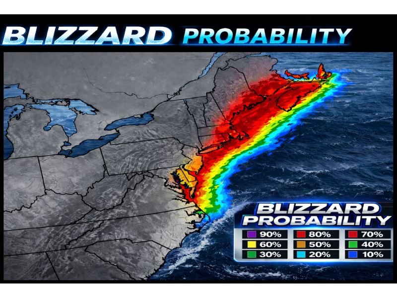
CAPE HATTERAS, NORTH CAROLINA — A developing storm offshore is raising early concern for the East Coast, with forecasters warning the system could rapidly intensify as it moves north and potentially meet full blizzard criteria in multiple locations.
Early Forecast Flags Rapid Strengthening Potential
The alert emphasizes that this is an early heads-up because of how quickly the storm could deepen once it begins moving north from the waters off Cape Hatteras. When coastal systems intensify fast, impacts can expand and shift in a short time window—turning a routine winter storm into a high-impact event across a broader region.
Blizzard Conditions Possible With Winds Over 50 MPH
Forecasters say wind gusts exceeding 50 mph are possible, especially along coastal areas. That kind of wind can significantly raise the risk of blowing and drifting snow, reduced visibility, and near-whiteout conditions at times. Even if snowfall totals vary by location, strong wind can make travel hazardous and emergency response more difficult.
Coastal Flooding and Power Outage Concerns Highlighted
Along with snow and wind, the outlook notes concern for coastal flooding in vulnerable shoreline areas as the storm strengthens and tracks north. In addition, strong winds and heavy, wet snow can increase the chance of tree damage and power outages, particularly where wind-driven snow loads build up on branches and lines.
Generator Safety Reminder Issued Ahead of Possible Disruptions
Because power disruptions are a realistic risk if the storm intensifies, residents were urged to take generator safety seriously. If using a generator during an outage, it must be properly ventilated and placed well away from the home to reduce the risk of deadly carbon monoxide exposure.
More Detailed Breakdown Expected Next
A more comprehensive breakdown is expected to follow, including where impacts may be greatest and which coastal areas could face the highest flooding risk. As the storm’s track and intensity become clearer, communities from the Mid-Atlantic into the Northeast may get sharper guidance on timing, snow bands, and wind threats.
If you live along the coast or have travel planned early next week, what preparations do you make first when a potential blizzard is on the horizon? Share what you’re watching for and join the conversation at SaludaStandard-Sentinel.com.