California, Texas, and Midwest States Face Busy Weather Pattern After February 13 as Multiple Storm Systems Spread Rain, Snow, and Severe Threats
UNITED STATES — Forecast models are signaling a significant increase in weather activity across much of the country after February 13, with multiple storm systems expected to arrive from the western United States before spreading east along varying paths.
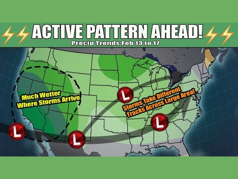
Both the GFS and European models show higher confidence in above-average precipitation developing first in western states, followed by an increasingly active pattern affecting large portions of the central and eastern United States.
Storm Systems Begin in the West With Wetter Conditions
Model guidance highlights the western United States, including California and surrounding states, as the first area to experience increased storm activity. This region shows the strongest signal for above-average precipitation as multiple systems move onshore.
As storms arrive in quick succession, confidence is highest that the West will see a notably wetter stretch compared to recent conditions.
Storm Tracks Diverge as Pattern Becomes More Active
After entering the West, forecast models show storm systems taking multiple different tracks as the overall weather pattern shifts. This variability increases the potential for active weather across a wide swath of the country rather than concentrating impacts in a single region.
Low-pressure systems are expected to travel through portions of Texas, the Plains, the Midwest, and the eastern United States, spreading precipitation over a large geographic area.
Snow and Severe Weather Both Possible
As colder air remains in place across northern regions while warmer air pushes northward, everything from snow to severe weather is on the table during this period.
Northern states may see snow depending on storm track and timing, while southern and central areas could experience thunderstorms or severe weather if instability increases.
February 13–17 Marks Key Window to Watch
The most active window highlighted by the data runs from February 13 through February 17, when repeated storm systems could impact travel, outdoor plans, and daily routines across several states.
Meteorologists stress that exact impacts will vary by location, but the overall signal points to a notably busy and unsettled stretch of weather nationwide.
Pattern Shift Ends Recent Quiet Weather
This setup marks a clear departure from the quieter pattern seen earlier in the month. With multiple storms in play and no single dominant track, the atmosphere is entering a phase where conditions can change quickly from one system to the next.
Residents across affected regions are encouraged to stay weather-aware as forecast details become clearer closer to each system’s arrival.
What kind of weather are you expecting where you live during this active stretch? Share your thoughts and experiences with us at SaludaStandard-Sentinel.com, where we continue tracking developing weather patterns across the United States.