California Storm System Targets Southern Coast With Flood Watch Issued for January 3–4 Across Los Angeles, Ventura, and Santa Barbara Counties
CALIFORNIA — A developing storm system is expected to impact Southern California over the weekend of January 3 and 4, prompting the Southern California Weather Force to issue a Flood Watch for several coastal and inland zones as rainfall increases across the region.
Forecasters say the system will arrive in multiple waves, with rain intensity increasing through Saturday and continuing into Sunday, particularly along the southern-facing mountain slopes and coastal counties.
Flood Watch Issued for Coastal and Inland Southern California Zones
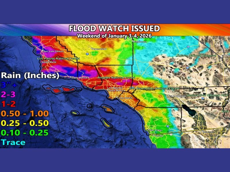
The Flood Watch applies to San Luis Obispo, Santa Barbara, Ventura, Los Angeles, and Orange counties, as well as portions of the Northern Inland Empire, including areas near Rancho Cucamonga, Cajon Pass, Fontana, and Yucaipa.
Rainfall maps indicate the highest totals will be concentrated along the coast and foothills, where 2 to 3 inches of rain are possible, with localized totals exceeding 3 inches in favored terrain.
Two Storm Impulses Expected Through the Weekend
Meteorologists expect two separate impulses to move through Southern California — one on Saturday and another on Sunday. This pattern is consistent with traditional Pacific storm systems affecting the region, but rainfall intensity may be amplified by favorable atmospheric dynamics.
Southerly mid-level flow is expected to enhance precipitation along the southern end of the coastal and transverse mountain ranges, increasing runoff potential in those areas.
Inland Empire and Desert Areas Expected to See Less Impact
The Inland Empire is forecast to experience a partial rain-shadow effect due to the Santa Ana Mountains, meaning rainfall totals should be lower compared to coastal zones. Forecast guidance shows reduced flood risk in inland valleys, with little to no flooding concerns at this time. Further east, most low desert areas are expected to remain largely dry as rainfall diminishes while the system moves eastward.
Thunderstorm Potential Due to Strong Upper-Level Jet
A 120 mph upper-level jet positioned within the storm’s lifting zone may provide enough atmospheric energy to support isolated thunderstorms, particularly during heavier rainfall periods. While widespread severe weather is not expected, embedded thunderstorms could briefly intensify rainfall rates, increasing localized flooding concerns.
Snow Levels to Remain High During This Event
Snow levels are forecast to remain elevated, meaning mountain locations such as Big Bear and surrounding passes are likely to see rain rather than snow during this system. Travel impacts related to snowfall are not expected with this event. Colder systems later next week may bring lower snow levels beginning around January 6, but those conditions fall outside the scope of this forecast.
Residents Urged to Monitor Conditions and Prepare
Officials advise residents in flood-prone areas to remain alert for changing conditions, especially near burn scars, urban drainage systems, and low-lying roadways. While widespread flooding is not guaranteed, the combination of terrain and rainfall intensity warrants preparation.
If you live in Southern California and experience heavy rain or localized flooding this weekend, share your observations and stay informed with continued coverage from SaludaStandard-Sentinel.com.