Brutal Wind Chills Expected Across the Southeast as Tightly Packed Isobars Signal Dangerous Arctic Air Surge Sunday Morning
SOUTHEAST UNITED STATES — A dangerous surge of Arctic air is tightening its grip across the Southeast this weekend, with meteorologists warning that closely packed isobars on forecast maps point to strong winds and brutal wind chills, especially during the early hours of Sunday morning.
Weather models show an intense pressure gradient setting up across much of the region, a classic signal that cold air will be accompanied by gusty winds capable of driving wind chill values well below actual air temperatures.
Why Meteorologists Are Focused on the Isobars
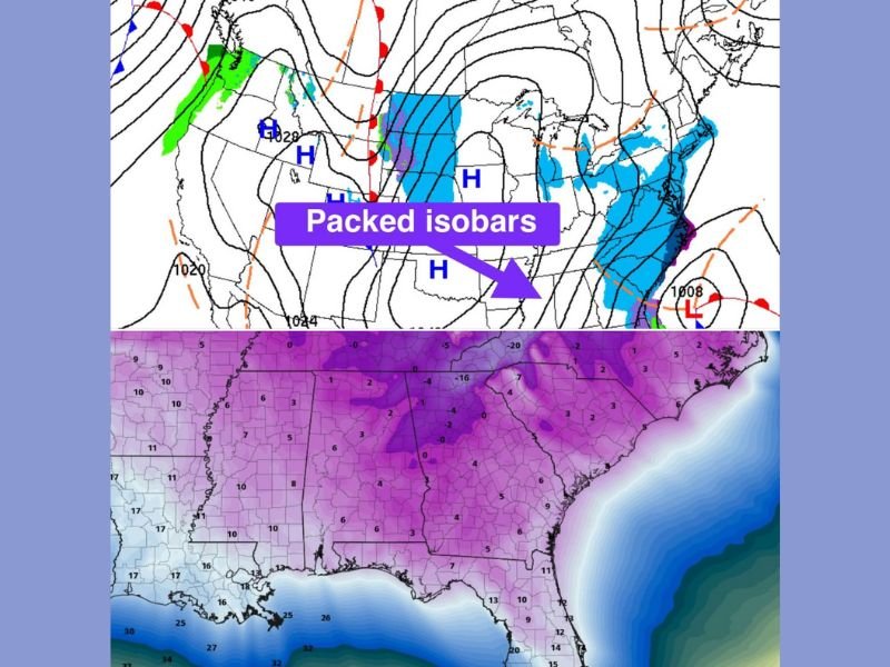
Isobars are the lines on a weather map that connect areas of equal atmospheric pressure. When those lines are spaced far apart, winds tend to be lighter. When they are packed tightly together, it indicates that pressure is changing rapidly over a short distance — a setup that almost always produces strong winds.
Current model guidance shows isobars packed unusually close together across the Southeast, a red flag for increasing wind speeds as Arctic high pressure presses southward and a departing low-pressure system pulls away to the east.
Wind Chills Expected to Turn Dangerous Sunday Morning
As colder air settles in overnight, the strengthening winds will dramatically reduce how cold it feels outdoors. Forecast data indicates that wind chills Sunday morning could plunge into dangerous territory, even in areas where temperatures alone might not seem extreme.
These conditions raise concerns for frostbite and hypothermia, particularly for anyone spending extended time outdoors or without adequate cold-weather protection.
Cold Air and Wind Combine for High Impact Event
The Arctic air mass behind this system is shallow but dense, allowing it to surge south quickly. With strong pressure differences driving winds, the cold will feel sharper and more punishing than a typical winter chill.
Forecasters note that this type of setup often catches people off guard because the wind, not just the temperature, becomes the primary threat.
Safety Concerns Extend Beyond the Cold
Strong winds combined with freezing temperatures can also stress infrastructure, including power lines and exposed pipes. Gusty conditions may worsen travel safety, particularly on bridges and elevated roadways where wind exposure is greatest.
Residents are urged to limit outdoor exposure, dress in multiple layers, cover exposed skin, and check on vulnerable neighbors as conditions worsen.
What to Watch Going Forward
Meteorologists will continue monitoring how long the pressure gradient remains in place. If isobars stay tightly packed longer than expected, dangerous wind chills could persist well into Sunday.
Stay alert for updated advisories and warnings as this Arctic surge continues to evolve.
How cold did it feel in your area this morning? Share your local conditions and stay informed with continued coverage from SaludaStandard-Sentinel.com.