Bitter Cold on Final Morning of 2025 as Wind Chills Plunge Into the Teens and Low 20s Across Texas, Louisiana, Mississippi, Alabama, Georgia, and Tennessee
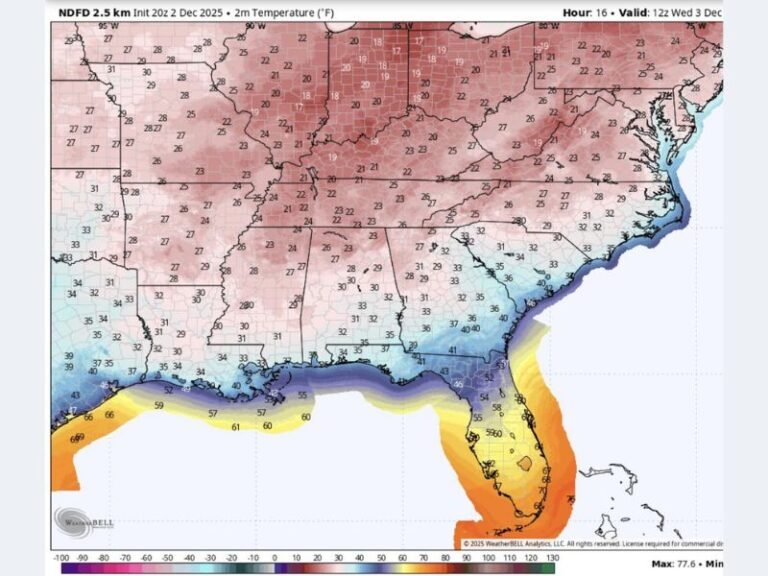
TEXAS — A powerful Arctic blast is set to deliver one of the coldest mornings of the season across the South, with wind chills dropping into the teens and low 20s from Texas to Tennessee on the final morning of 2025. Forecasters say the air mass is unusually strong for late December and will bring hazardous conditions, sharp temperature drops before sunrise, and widespread impacts across multiple Southern states.
Wind Chills Will Be Brutal Across the Region
The latest forecast map shows wind chills early Tuesday morning falling sharply across:
- North Texas and Dallas region: 21–25°F
- Louisiana: widespread low-to-mid 20s
- Mississippi: 18–24°F
- Alabama: 19–24°F
- Georgia (including Atlanta): 18–23°F
- Tennessee: 10–18°F in many northern counties
Farther north, the cold intensifies into the single digits, with selected mountain areas dropping even lower. Even locations closer to the Gulf Coast — typically shielded from deep freezes — will wake up to wind chills in the upper 20s to near freezing, a stark contrast to typical late-December warmth.
Arctic Air Expected to Make Travel and Morning Activities Difficult
Meteorologists warn that this blast will not be mild or brief. A combination of strong overnight radiational cooling and persistent northerly winds will make early morning activity uncomfortable and, in some cases, dangerous.
Residents are urged to:
- Limit early-morning outdoor exposure
- Dress in winter layers
- Protect pets and sensitive plants
- Check on neighbors and elderly relatives
Forecasters note the cold will feel “sharp,” especially in urban corridors like Atlanta, Birmingham, Jackson, and Dallas, where wind funneling can intensify the chill.
State-by-State Weather Snapshot
While the original social commentary circulating online expressed the cold in humorous terms, the underlying meteorological situation is serious:
Texas
Wind chills in the low-to-mid 20s will sweep through Dallas–Fort Worth and surrounding counties. Those commuting early may face icy wind gusts and frigid conditions.
Louisiana
Wind chills near the low 20s will blanket much of the state. Coastal areas may see slightly higher values but still colder than average.
Mississippi
Forecast wind chills in the teens and low 20s will make pre-dawn travel particularly uncomfortable, especially in rural areas.
Alabama
Wind chills from 19–24°F will affect most communities, with exposed skin cooling rapidly in the early morning air.
Georgia
Atlanta and northern Georgia will see some of the most widespread impacts, with wind chills dropping into the upper teens.
Tennessee
Northern Tennessee will experience some of the coldest air in the region, with wind chills from 10–15°F and even lower in elevated terrain.
Why This Cold Surge Matters
Though short-lived, this Arctic push is notable because:
- It arrives at the end of December, when many residents may not expect severe cold
- It covers a wide area from Texas to the Carolinas
- It brings prolonged subfreezing wind chills for several hours
Meteorologists say this pattern resembles a broader national cold plunge positioned over the eastern United States, with southern states caught directly under its influence.
Looking Ahead
Temperatures will gradually recover after sunrise, but most regions will remain below average through the afternoon. A modest warmup is expected later in the week, though overnight lows will stay chilly.
Residents across the Southeast are encouraged to exercise caution, report local hazards, and follow updates from trusted weather sources throughout the cold period. Share your cold-weather photos, conditions, and local experiences at SaludaStandard-Sentinel.com.