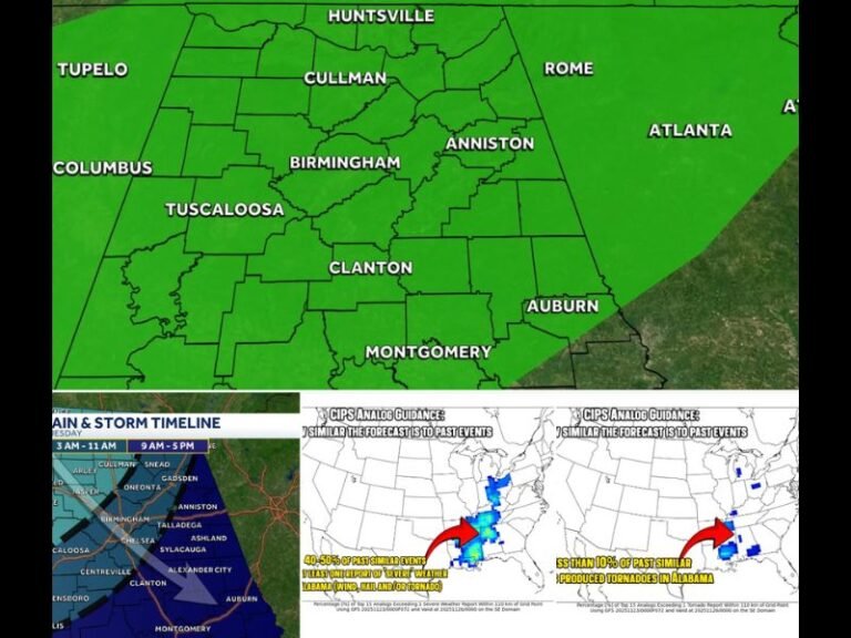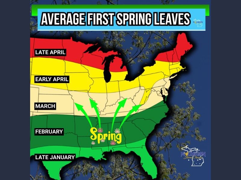
Average First Spring Leaves Map Shows Sharp North–South Divide as Southern States Turn Green in February While Upper Midwest Waits Until Late April
UNITED STATES — A newly released average first spring leaves map highlights a clear seasonal progression across the country, showing spring vegetation advancing northward over nearly three months, from late January in the Deep South to late April across the Upper Midwest and northern New England.
The data illustrates how latitude, climate, and lingering winter conditions dramatically influence when trees typically produce their first leaves each year.
Late January to February: Spring Begins in the Deep South and Gulf Coast
According to the map, southern Texas, Louisiana, Mississippi, Alabama, Georgia, and Florida fall into the late January and February zones, making them the first regions in the country to experience widespread tree leaf-out.
These areas benefit from warmer winter temperatures, shorter cold spells, and longer growing seasons, allowing spring vegetation to emerge while much of the country remains dormant.
March: Spring Pushes Into the Lower Midwest and Southern Appalachians
By March, the spring leaf-out zone expands northward into parts of Arkansas, Tennessee, Kentucky, southern Missouri, southern Virginia, and North Carolina.
This stage represents the transition phase, where winter loosens its grip but cold snaps can still temporarily slow vegetation growth.
Early April: Broad Leaf-Out Across the Central and Mid-Atlantic States
The map shows early April as the dominant leaf-out window for a wide swath of the country, including:
- Much of the central Midwest
- Parts of the Ohio Valley
- Large sections of the Mid-Atlantic
This zone marks the point where spring becomes firmly established for millions of people, with trees consistently budding and landscapes rapidly turning green.
Late April: Spring Arrives Last in the Upper Midwest and Northern States
The final region to see average first spring leaves is the Upper Midwest and northern tier, including:
- Northern Minnesota
- Northern Wisconsin
- Much of Michigan
- Northern New England
These areas remain in winter dormancy far longer due to colder temperatures, lake influence, and frequent late-season freezes, pushing leaf emergence into late April.
Why the Timing Varies So Widely Across the U.S.
The map reflects long-term averages, not exact dates, and actual leaf-out timing can vary year to year based on:
- Late winter cold snaps
- Early spring warm spells
- Snow cover and soil temperatures
- Tree species and elevation
Still, the data clearly shows a consistent national pattern: spring moves north slowly, not evenly.
What This Map Explains About Spring Expectations
The visualization helps explain why spring can feel dramatically different depending on location. While some southern states are fully green before winter even ends elsewhere, northern regions often wait weeks longer for visible signs of seasonal change.
Rather than arriving all at once, spring unfolds in stages—starting in the Deep South, spreading through the central states, and finally reaching the Upper Midwest and northern regions last.