Arctic Cold Front to Bring Freezing Windchills Monday Morning Across Texas and Oklahoma
TEXAS & OKLAHOMA — A sharp drop in temperatures is expected to kick off the workweek as an Arctic cold front sweeps across Texas and Oklahoma, bringing freezing windchills and a jarring change from the warmer conditions seen in recent days.
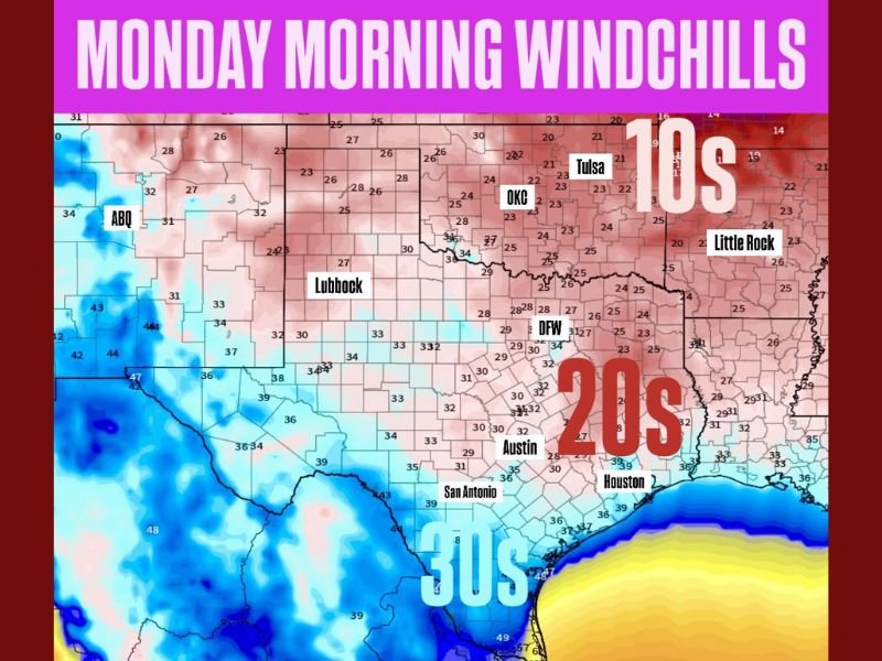
According to Meteorologist Chris Nunley, most areas will feel temperatures plunge into the 10s, 20s, and 30s by early Monday morning. “The start of the upcoming workweek will be cold across Oklahoma and Texas,” Nunley said. “Most folks will have windchills in the 10s–30s coming off several days with temperatures above normal.”
Temperatures Drop Sharply Overnight
The coldest readings are expected in northern Oklahoma, including Tulsa and Oklahoma City, where windchills may dip into the low teens. Farther south, Dallas-Fort Worth and Austin could feel temperatures in the 20s, while San Antonio and Houston are likely to see windchills in the 30s.
The temperature swing will be especially noticeable for residents in central and southern Texas, where daytime highs last week hovered well above normal for November.
Arctic Air Moves in Behind Front
Forecasters say the Arctic air mass pushing southward will bring clear skies and dry conditions, but with brisk north winds making it feel much colder than the thermometer shows. The front’s passage will mark the first significant cold spell of the season for much of the southern Plains.
In Lubbock, temperatures could fall into the upper 20s, while areas farther west near Abilene and Midland may experience similar lows. Cities closer to the Gulf Coast, including Corpus Christi and Galveston, are expected to remain in the 40s but will still feel the chill.
Safety Precautions and Local Advice
Residents are urged to take precautions as temperatures fall rapidly overnight:
- Bundle up in layers if heading out early Monday.
- Bring pets indoors and provide adequate shelter from the cold.
- Cover outdoor plants and faucets to prevent frost damage.
Meteorologists do not expect significant precipitation with this system, though patchy frost could form in northern and central areas where skies clear out before sunrise.
Extended Outlook
Forecasters expect the cold to linger into midweek, with gradual warming possible by Thursday. Another round of cold air could arrive next weekend depending on how the upper-level pattern evolves.
For now, residents across Texas and Oklahoma should prepare for a sharp and sudden start to winter-like temperatures.
Stay updated on developing weather conditions at SaludaStandard-Sentinel.com for the latest forecasts and advisories.