Alabama Set for Arctic Blast December 14–15 Before Pattern Shift Brings Warmer Days Through Christmas
ALABAMA — Early December may have felt unusually chilly, but meteorologists note that Birmingham’s first 11 days of the month actually ranked as the 37th warmest start on record, showing how misleading early-season cold can be. That pattern ends sharply this weekend. A significant Arctic blast arriving Sunday into Monday (Dec. 14–15) will deliver the coldest temperatures so far this season before a pronounced warm-up settles in for Christmas week.
Arctic Air Set to Move In Sunday and Monday
The upcoming cold surge will drive sharply falling temperatures across Alabama, producing:
- Feels-like temperatures in the 20s by Sunday afternoon
- Morning lows in the 10s and 20s statewide by Monday
- 20 to 30 consecutive hours below freezing from Sunday through Monday
This will be the strongest cold outbreak before the holiday, but forecasters stress it will be short-lived.
No Chance of Christmas Snow for Alabama
Meteorologists state clearly that there will be no Christmas snow this year.
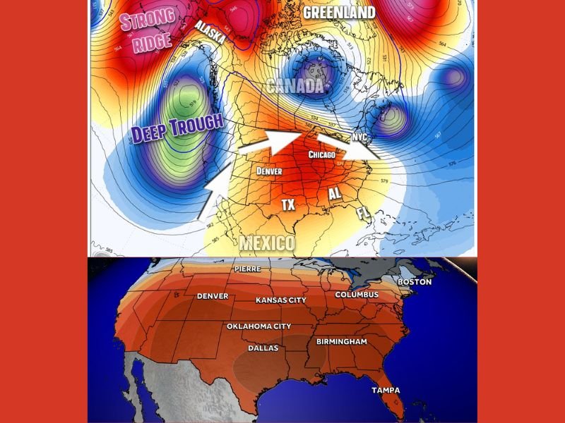
A strong ridge building in the West and a developing low near Alaska will construct a jet stream pattern that blocks severe cold from reaching Alabama through December 25, ensuring a milder final stretch to the month.
Forecast Timeline for the Week Ahead
Saturday
- Highs reach the lower to middle 60s
- Increasing afternoon clouds
- Slight chance of sprinkles late
Sunday
- A few early showers
- Sharp temperature drop by midday
- Feels-like readings fall into the 20s
- Lowest temperature expected before midnight
Monday
- Hard freeze statewide
- Morning lows in the 10s and 20s
- Afternoon highs only in the lower 40s
- 20 to 30 hours below freezing possible across central Alabama
Tuesday
- Another morning freeze
- Highs rebound into the 50s under sunshine
Wednesday
- Morning lows in the mid-to-upper 30s
- Highs in the upper 50s
- About a 20 percent chance of light showers
Thursday
- Mild morning in the 40s
- Scattered showers possible
- Highs reach the lower and middle 50s
Friday
- Morning lows in the 30s and 40s
- Afternoon highs in the 50s
Pattern Shift Will Bring Warmer Days Through Christmas
Following the Arctic blast, models show a major warm-up as a strong ridge takes hold across the western U.S. and a deep trough anchors near Alaska.
This configuration directs warmer west-to-east flow across the South, giving Alabama a milder-than-normal Christmas week with temperatures trending above seasonal averages.
Residents preparing for next week’s cold blast, and those monitoring the upcoming warm-up, are encouraged to share observations and weather updates with the community at SaludaStandard-Sentinel.com.