Alabama, Georgia, Tennessee, and the Carolinas Could See Light Snow Chances Around December 20 as Forecast Models Hint at a Southern Dusting
ATLANTA, Ga. — After weeks of dry and chilly conditions, new ensemble forecast models are stirring excitement across the South — suggesting a potential for light snow around December 20–21 across parts of Alabama, Georgia, Tennessee, and the Carolinas.
While far from a guarantee, multiple model runs — including the GFS, ECMWF, and CMC ensembles — are beginning to show small but notable hints of winter precipitation developing along a cold front late next week.
Forecast Models Show Flirting Snow Potential
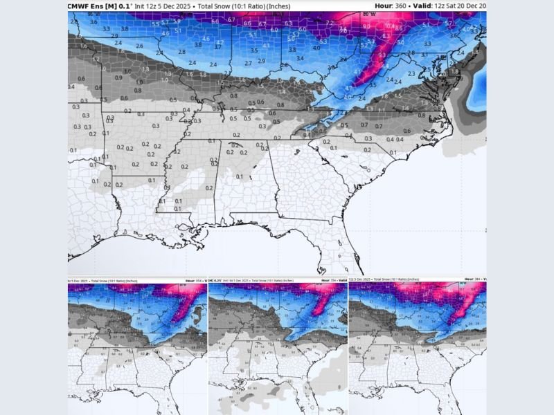
According to the European ECMWF ensemble data released December 5, light snow accumulation ranging from a dusting up to one inch could be possible in some areas, especially across northern Alabama, central Tennessee, and the southern Appalachian foothills.
The GFS model echoes a similar pattern, showing a narrow band of potential snow or wintry mix stretching from Arkansas and northern Mississippi into Georgia and the western Carolinas by the weekend of December 20–21.
“We’re not talking about a blizzard, but we’re starting to see consistency in the ensembles,” said meteorologist Caleb Davis. “Even a few flakes would be enough to get attention in the Deep South, especially this close to Christmas.”
Expected Impacts by State
- Alabama: Light flurries or a dusting possible north of Birmingham and into Huntsville late December 20.
- Georgia: North Georgia could see trace amounts, especially in higher elevations. Atlanta’s snow odds remain low but not zero.
- Tennessee: Northern and central regions, including Nashville and Knoxville, may see up to one inch of snow depending on moisture timing.
- The Carolinas: Western North Carolina could see light snow, while South Carolina’s upstate region might only see cold rain.
Forecasters caution that confidence remains low due to the event being more than a week away, but they agree that cold air and a passing disturbance will align close enough to warrant monitoring.
Meteorological Setup: Cold Air Meets Southern Moisture
Meteorologists attribute this setup to a high-pressure system diving south from the Midwest, colliding with Gulf moisture moving northeast.
If timing aligns, light snow showers could occur overnight Friday into early Saturday (December 20–21), particularly where surface temperatures dip below freezing.
However, even slight shifts in timing could turn potential snowfall into a cold rain event instead.
“It’s the kind of system that makes Southern snow forecasting tricky,” said Davis. “If the cold air arrives just a few hours too late, it’s all rain. But if it syncs up — you get those surprise dustings.”
Community Buzz and Cautious Optimism
Social media buzz has already started, with Southerners jokingly preparing for “Snowpocalypse 2025: Biscuit Edition.”
While experts dismiss talk of a major snowstorm, they note that the holiday timing and low thresholds for excitement make even a light dusting headline-worthy.
“All it takes is one flake to shut down half the South,” meteorologist Ryan Hall quipped. “We’ll see if this one delivers or teases like so many before it.”
Looking Ahead
Beyond this short-lived event, longer-range forecasts suggest a reinforcing Arctic front could follow before Christmas, keeping temperatures below normal across much of the Southeast through late December.
Whether this marks the start of a more active winter pattern remains to be seen, but for now, hope is cautiously alive for Southerners wishing for a rare white holiday season.
Stay tuned for further updates and refined model guidance as the potential December 20–21 snow event approaches.