Alabama Could See Wednesday Morning Flurries North of Birmingham as Rain Exits and Temperatures Hover Above Freezing
ALABAMA — Parts of North Alabama could see a round of light snow flurries or brief snow showers Wednesday morning, mainly north of the Birmingham metro, as a rain system moves out and colder air filters in behind the front. The setup is expected to be more of a “look at the flakes” moment than a disruptive winter event, with temperatures forecast to remain above freezing for most locations.
What the Timeline Looks Like From Tuesday Into Wednesday
The outlook described in the forecast notes a milder day on Tuesday, with many communities sitting in the 50s to lower 60s ahead of incoming rain. Once that rain clears and the front passes, there may be just enough lingering moisture for precipitation to flip briefly to flurries early Wednesday morning, especially in the higher terrain and northern counties.
This is a common post-front scenario in the Deep South: rain exits, cold air arrives, and a narrow window opens where a few snowflakes can mix in before the atmosphere dries out.
Where Flurries Are Most Likely in North Alabama
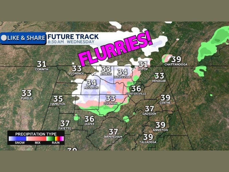
The “Future Track” graphic highlights the best chance for flurries in areas north of Birmingham, particularly across portions of north-central and northeast Alabama. The flurry zone shown includes communities such as Cullman, Huntsville, and nearby areas, with additional light wintry precipitation indicated near towns like Athens and Moulton.
Temperatures on the map in the flurry zone are generally shown in the low to mid-30s for many northern communities at the time of the graphic, while areas farther south—closer to Birmingham—are depicted warmer, suggesting the best opportunity for flakes is likely to stay north and northeast of the city.
Accumulation Expectations: Mostly Nothing, Maybe a Dusting on Grass
The forecast message is direct about what residents should expect on the ground: accumulation is expected to range from mostly nothing to a small amount on grassy surfaces. Even in spots where flurries are visible, the combination of above-freezing temperatures and limited moisture should make it difficult for snow to stick to roads in a meaningful way.
If anything does collect briefly, it would most likely show up on elevated or colder surfaces—like grassy patches, decks, or roofs—before melting quickly once daylight increases and the atmosphere continues to dry.
Why This Looks Like a Brief Flurry Window, Not a Major Winter Storm
The key limiting factors in this setup are temperature and duration. While northern towns may flirt with the low 30s early Wednesday, the forecast indicates temperatures should stay above freezing overall, reducing the odds of long-lasting impacts. Just as important, the available moisture appears limited once the main rain shield pushes east, so the flurry period may be short and spotty rather than widespread and sustained.
In other words, the atmosphere may be capable of producing flakes, but not the kind of prolonged snowfall needed to create travel problems across a broad area.
Practical Advice for Drivers and Early-Morning Commuters
Even when accumulations are minimal, flurries can still reduce visibility briefly—especially at daybreak. Drivers in northern counties should stay alert for patchy reduced visibility and cooler air moving in behind the front. While the forecast does not suggest a widespread icing issue, bridges and overpasses can cool faster than surrounding surfaces, so cautious driving is still smart during the early morning window.
For most residents, the bigger headline may simply be the novelty: flakes in the air, a quick reminder that winter can still show up in Alabama even when it doesn’t stick around for long.
What’s the weather doing where you live—have you seen flurries in your part of Alabama before, or do you expect this one to fizzle out? Share what you’re seeing and follow ongoing regional coverage at SaludaStandard-Sentinel.com.