Alabama Braces for Thursday Thunderstorms After Extended Freeze Across Birmingham and Huntsville
ALABAMA — Residents across northern and central Alabama are in for a dramatic weather turnaround this week. Following a stretch of freezing temperatures that kept Birmingham and Huntsville below 32°F for more than 18 hours, rain and thunderstorms are expected to roll through the state on Thursday afternoon and evening.
Meteorologist Chris Jones noted that the sharp transition from bitter cold to wet and stormy weather highlights the volatility of December’s climate patterns across the Southeast.
Freeze Lingers Into Monday Morning
Temperatures plummeted Sunday afternoon as Arctic air settled over the region. Birmingham fell below freezing at 4 p.m. Sunday, and forecasters expect it to remain below 32°F until around 9–10 a.m. Monday.
In Huntsville, temperatures dropped just before dawn Sunday, falling below 32°F at 5 a.m., with a return above freezing not expected until 11 a.m. Monday.
“This was one of the longest continuous freezes of the season so far,” Jones said. “Residents should check pipes, protect outdoor plants, and make sure vulnerable pets and livestock are sheltered through Monday morning.”
Storm System Taking Shape for Thursday
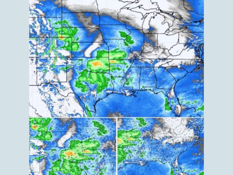
The next major weather event comes later in the week, as a new storm system builds across the Mississippi Valley and moves eastward into Alabama on Thursday.
European weather models show a band of scattered thunderstorms and lightning forming across central and northern Alabama, peaking between 3 p.m. and 8 p.m.
Model data suggests strong upper-level winds — over 15,000 feet above the surface — will enhance storm development, bringing gusty conditions and heavy rainfall at times.
“While we don’t see a strong severe weather signal right now, this kind of setup can change quickly,” Jones explained. “It’s the kind of system that deserves attention because small shifts in timing or instability could create isolated stronger storms.”
Current Forecast Highlights
- Freeze Warning: Subfreezing temperatures continue overnight through Monday morning across north and central Alabama.
- Thursday Forecast: Rain and thunderstorms likely in the afternoon and evening; isolated lightning possible.
- Severe Weather Potential: Low for now, but forecasters will monitor for rapid developments as temperatures rebound midweek.
- Wind Speeds: Upper-level wind maps show 50–60 knot flow (around 60–70 mph) over the Southeast by Thursday evening, a sign of potential storm organization.
Temperature Rebound and Rain Relief
As cold air retreats, Alabama’s temperatures will climb into the 50s and 60s by midweek, offering relief from the deep freeze. However, the warmer air will also add fuel for the Thursday storm system, making it a quick shift from icy mornings to muggy afternoons.
“This kind of temperature whiplash is typical for Alabama in December,” Jones said. “It’s a reminder to stay prepared — winter can give way to spring-like storms in just a few days.”
Safety Tips and Outlook
Residents are advised to:
- Allow faucets to drip overnight until temperatures rise above freezing.
- Secure outdoor furniture and light objects ahead of Thursday’s potential wind gusts.
- Check forecasts daily as models refine timing and storm strength.
Forecasters say more rain may follow into the weekend, but conditions are expected to stabilize by early next week.
Stay tuned for continuing updates on Alabama’s evolving weather pattern at SaludaStandard-Sentinel.com.