Alabama and Tennessee Face Two Rounds of Severe Storm Risk This Week as Monday Brings Marginal Threat Before Stronger Wednesday System
ALABAMA — Forecasters are tracking two potential rounds of severe weather this week across parts of Alabama and the broader Southeast, with the first threat arriving Monday and a stronger system expected to develop by midweek.
Meteorologists say North Alabama could experience storm development on both Monday and Wednesday, though the timing, intensity, and exact impacts remain somewhat uncertain as weather models continue to evolve.
While Monday’s threat appears relatively limited, forecasters warn that Wednesday’s system could bring a broader severe weather risk across multiple states.
Monday Brings a Marginal Severe Weather Risk
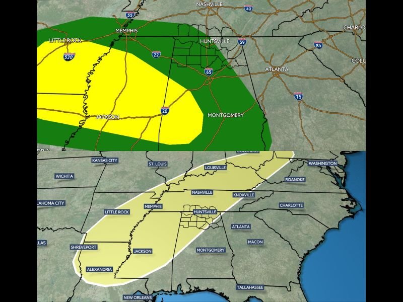
The Storm Prediction Center has placed portions of North Alabama in a Level 1 “Marginal Risk” for severe weather on Monday, indicating isolated storms could become strong during the afternoon and evening hours.
Several clusters of thunderstorms are expected to form across parts of the Southeast throughout the day. These storms may gradually track across the region, bringing the possibility of strong wind gusts and small hail if they maintain organization.
However, meteorologists say the situation is uncertain for North Alabama specifically, as some forecast models suggest much of the storm activity could remain farther south and southwest.
If storms do push farther north into the Huntsville region and surrounding communities, damaging winds would likely be the primary concern, with hail also possible in stronger storm cells.
Wednesday System Could Bring Widespread Severe Threat
Attention is already turning to a second weather system expected to arrive by Wednesday, which could produce a more widespread severe weather setup across parts of the Southeast.
Current projections suggest rain and thunderstorms may begin developing late Wednesday afternoon, continuing into the evening and potentially lasting overnight. Unlike Monday’s limited threat, this midweek system could bring multiple severe hazards, including:
- Damaging wind gusts
- Large hail
- The possibility of isolated tornadoes
Meteorologists say the broader region from Mississippi through Alabama and into Tennessee may fall within the corridor of strongest storm activity.
Forecast Details Still Developing
While the overall pattern points toward a more significant storm setup by Wednesday, forecasters caution that smaller-scale details remain uncertain.
Changes in temperature, moisture levels, and atmospheric energy will ultimately determine how strong storms become and exactly where they develop. As a result, meteorologists will continue monitoring new model data over the next several days to refine the forecast.
Residents Urged to Stay Weather Aware
With two potential rounds of storms expected this week, residents across Alabama and neighboring states are encouraged to stay updated on forecast changes and severe weather alerts.
Even marginal risk events can produce isolated severe storms capable of strong winds or hail, while midweek conditions could bring a higher impact weather scenario if the system strengthens.
Officials recommend keeping weather notifications enabled and having a plan in place should warnings be issued. Stay with SaludaStandard-Sentinel.com for the latest updates as meteorologists continue tracking developing severe weather across the Southeast.