Active Mid-February Storm Track Could Bring Multiple Systems, With Snow North and Strong Storms South
UNITED STATES — Middle February is starting to look more active than normal as western troughing becomes established and repeatedly “reloads,” a pattern that often supports multiple storm systems moving across the country. While exact timing and placement are still changing between model runs, the overall signal is that the storm track could become busy roughly about a week from now, with snow on the colder side of each system and a risk of strong to severe storms on the warmer side.
Why “Western Troughing” Matters for Storm Chances
A deep trough in the western U.S. is like an engine for storm development. When it holds in place and keeps re-forming, it can keep sending disturbances out into the Plains and then toward the Midwest and East. In setups like this, the atmosphere can cycle through one system after another, rather than a single one-and-done event.
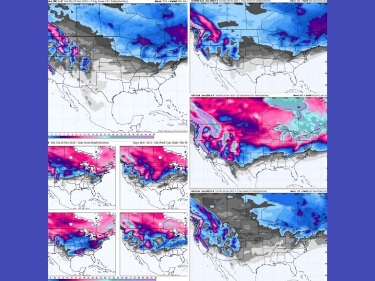
What the Mid-February Map Is Hinting At
The mid-level pattern shown for around Feb. 16 suggests a broader, energized flow that favors an active storm corridor from the southern/central U.S. toward the Ohio Valley and farther east. The graphic also hints at multiple systems in play, with one system moving out, while additional energy lingers back to the west—signaling that the pattern may not quiet down quickly.
What This Could Mean on the Ground
Even without locking in exact city-by-city details yet, the impacts typically break down like this:
- North of the storm track: colder air supports snow and wintry travel, especially if a system strengthens and pulls moisture into the cold side.
- Along and south of the track: warmer, humid air can fuel heavy rain and thunderstorms, and in some cases severe weather, depending on how much Gulf moisture returns.
What to Watch Over the Next Several Days
Because this is medium-range guidance, the most important trend to watch is not one single day—but whether forecasts continue to show:
- A repeating storm track
- Multiple systems spaced a couple days apart
- A clear split between snow potential north and storm potential south
We’ll keep tracking how this pattern sharpens. If you’ve got travel plans or outdoor work in the second half of February, it’s a good time to start paying closer attention to updates at SaludaStandard-Sentinel.com.