Severe Thunderstorms Sweep Across Southern California With Rotating Cells Detected Near Los Angeles
LOS ANGELES, CALIFORNIA — A new round of severe thunderstorms is hitting Southern California this morning, with radar data showing rotating supercells, heavy rainfall, and lightning across Los Angeles County, Orange County, San Diego County, and the Inland Empire.
Meteorologist Raiden Storm from the Southern California Weather Force confirmed that the Severe Thunderstorm Watch remains in effect for much of the region as unstable air and southeast surface winds fuel storm development.
Supercells and Rotation Detected
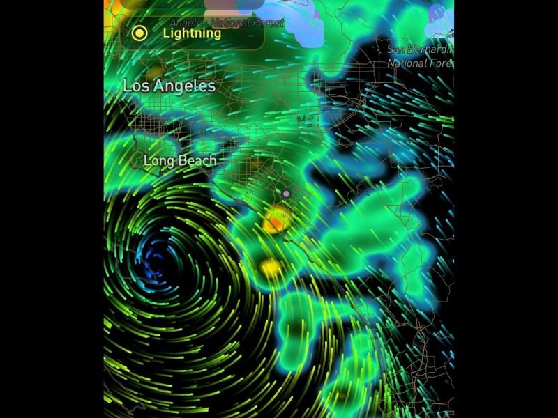
According to live radar imagery shared via the ZoneWatch app, several strong storm cells are forming near Los Angeles and Long Beach, showing rotation signatures that could intensify into stronger storms through the morning hours.
“Based on the ZoneWatch app, supercells forming in LA, OC, and SD are now showing rotation with this line,” Storm said. “A number of you will report thunderstorms soon.”
The radar indicates strong wind convergence and pockets of heavy rainfall offshore moving inland, signaling the potential for frequent lightning, small hail, and gusty winds.
Areas Under Watch
The Southern California Weather Force issued the Severe Thunderstorm Watch for the following areas:
- Los Angeles County
- Orange County
- San Diego County
- The Inland Empire (Riverside and San Bernardino Counties)
- High Desert and Cajon Pass regions
These areas are expected to experience the most intense activity through Friday morning, with the storm gradually weakening by midday.
What Residents Should Expect
Residents can expect:
- Heavy rain bursts leading to brief street flooding
- Frequent lightning and thunder
- Wind gusts exceeding 50 mph in localized cells
- Possible small hail and brief rotation in stronger storms
While the overall tornado risk remains low, meteorologists caution that isolated rotating updrafts could produce brief, weak spin-ups — particularly near the coast and foothills.
Tracking the System
The ZoneWatch radar and alert system continues to monitor evolving storm activity. Locals are encouraged to use the radar portal for real-time updates:
- Radar: radar.zonewatchpro.com
- App Download: zonewatchpro.com/download
Raiden Storm, President of the National Weather Force, noted that “storms like this are rare for late November but not unheard of. Conditions align perfectly for active convection this morning before tapering later today.”
For continuous severe weather coverage and safety updates, stay with SaludaStandard-Sentinel.com.