Strong Storm System to Bring Heavy Rainfall, Flash Flooding Risk and Possible Severe Weather to Texas by Midweek
TEXAS – A vigorous storm system tracking from the Desert Southwest into Texas this week is expected to bring widespread heavy rainfall, flash flooding, and the potential for severe thunderstorms, especially on Thursday. Meteorologists report that the atmosphere over Texas will contain near-record moisture levels for November, increasing the risk for intense rainfall rates and multiple rounds of storms.
Multiple Rounds of Storms Begin Wednesday Afternoon
Forecast models show showers and thunderstorms developing as early as Wednesday afternoon and evening, becoming more widespread overnight into Thursday. Ample moisture will stream into Texas ahead of the system, helping to fuel storm development across much of the state.
Weather analysts expect scattered storms Wednesday, but the more significant and organized activity is anticipated on Thursday as the system strengthens.
Heavy Rainfall Likely With Widespread 2–3 Inches, Locally Higher
Atmospheric moisture content will be unusually high, creating conditions supportive of heavy, persistent rainfall. Forecasters estimate:
• Widespread rainfall totals of 2–3 inches
• Locally higher amounts possible
This level of moisture, combined with strong lift from the incoming storm system, will make flash flooding a concern across both urban and rural areas. The risk increases where training thunderstorms—storms repeatedly forming and moving over the same region—develop along the system’s boundary.
Severe Thunderstorm Potential Remains Uncertain but Possible
While heavy rainfall is the most confident prediction, forecasters also note that severe thunderstorms are possible, especially given the strong winds aloft and the intensity of the incoming system. Damaging winds appear to be the primary severe threat at this time, though hail and isolated stronger storms cannot be ruled out.
Analysts emphasize that details regarding any organized severe threat remain uncertain, and updated forecasts will become clearer as the system approaches midweek.
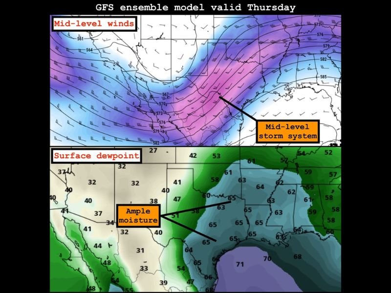
Mid-Level Winds and Deep Moisture Will Enhance Storm Strength
Forecast maps show a strong mid-level storm system positioned over Texas on Thursday, with intense mid-level winds helping to organize storm development. At the surface, deep moisture is already in place with dewpoints climbing into the upper 60s and low 70s, which will enhance storm strength and rainfall efficiency.
This combination of mid-level energy and surface moisture sets the stage for a high-impact weather period across much of Texas late Wednesday through Thursday evening.
Residents should monitor local forecasts carefully and be prepared for potential flooding, especially in areas prone to rapid water rise.
Have you experienced major storm events in your part of Texas this year? Share your thoughts and stay connected with SaludaStandard-Sentinel.com for continuing updates.