Strong Storm System Expected to Sweep Across Texas, Arkansas, and Louisiana Next Thursday Bringing Heavy Rain and Thunderstorms
DALLAS, Texas — Meteorologists are tracking a developing weather system expected to bring a strong line of storms and widespread rainfall across Texas, Arkansas, and Louisiana by Thursday, November 21. The late-week system could mark one of the first significant fall storm events tied to La Niña–driven weather patterns this season.
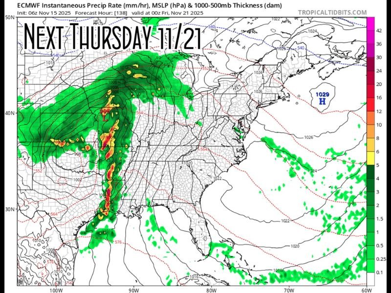
Forecast Models Indicate Major Storm Development
According to new model data from the European Centre for Medium-Range Weather Forecasts (ECMWF), a deep low-pressure system will form over the Central United States, stretching from the Midwest down to the Gulf of Mexico. As this low tracks eastward, it will drag a cold front through the Southern Plains, triggering a line of strong thunderstorms.
The forecast map shows a solid band of heavy rain and embedded thunderstorms extending from eastern Texas through Arkansas and into western Louisiana by late Thursday. The system is expected to continue eastward through Friday, potentially affecting parts of Mississippi and Alabama into the weekend.
Meteorologists note that La Niña patterns, which often dominate fall and winter seasons, can enhance such storm systems by creating sharp temperature contrasts between warm Gulf air and incoming Arctic fronts.
Heavy Rain and Thunderstorm Potential
Early outlooks suggest that parts of Texas, Arkansas, and Louisiana could see 1–3 inches of rain, with locally higher amounts near the heaviest storm bands. The line of storms could also produce gusty winds, frequent lightning, and isolated pockets of severe weather.
- Texas: Storms expected to arrive Thursday morning in eastern regions, including Houston, Tyler, and Dallas, before spreading east.
- Arkansas: Central and southern areas — including Little Rock and Pine Bluff — could see strong thunderstorms and locally heavy downpours.
- Louisiana: Western and northern regions may experience the brunt of rainfall Thursday night into early Friday.
Meteorologists caution that these conditions could lead to minor flash flooding, particularly in low-lying or poorly drained areas.
Timing and Movement
The model shows the storm system stretching across hundreds of miles, with the cold front moving steadily eastward. Thunderstorms are likely to form along the front by Thursday afternoon, intensifying as the front interacts with Gulf moisture.
By Thursday night, the system is projected to move across eastern Texas and southern Arkansas, reaching Louisiana and Mississippi by early Friday morning.
Once the system passes, cooler and drier air is expected to settle in across the region — a sign of the transitioning weather pattern leading into Thanksgiving week.
La Niña Pattern Driving Late Fall Instability
Meteorologists point out that this setup aligns with a La Niña-influenced weather regime, which tends to produce active storm patterns in the Southern U.S. during late fall and early winter.
This phase typically brings warmer-than-normal Gulf waters and strong jet stream interactions, both of which can amplify rainfall and storm strength.
“This is a classic La Niña setup,” weather analysts from SpaghettiModels.com noted. “Deep troughing over the central U.S. and a surge of Gulf moisture combine to bring heavy rain and occasional severe weather — something we’ll be watching closely next week.”
Stay Weather Aware
Although it’s still several days away, forecasters emphasize the importance of staying alert as timing and severity could shift with newer model updates. Residents across Texas, Arkansas, and Louisiana should monitor forecasts closely, especially those in flood-prone areas.
The National Weather Service (NWS) will issue watches and warnings as needed once confidence increases in the system’s strength and track.
Residents are advised to prepare now — secure outdoor items, check local drainage systems, and ensure weather alerts are enabled on mobile devices.
Stay with SaludaStandard-Sentinel.com for continuing updates on this developing storm system and other regional weather alerts.