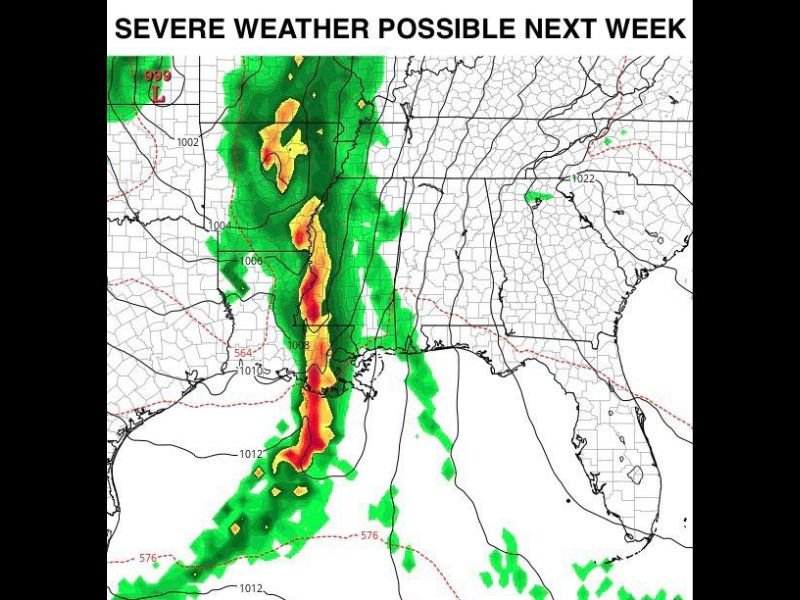
Severe Storms Forecast to Hit Louisiana, Mississippi, and Alabama Late Next Week, Meteorologists Warn
JACKSON, Miss. — Meteorologists are monitoring a developing weather system expected to bring a line of strong to severe storms across Louisiana, Mississippi, and Alabama late next week. Forecast models indicate the storm front could move through the Deep South between Thursday night and early Friday (Nov. 20–21), potentially producing heavy rain, gusty winds, and isolated tornadoes.
Developing Storm System Targets the Deep South
Weather experts say the system will form as a cold front sweeps across the central United States, tapping into warm, humid air from the Gulf of Mexico. This combination will create favorable conditions for thunderstorms and severe weather, especially across the Lower Mississippi Valley and Gulf Coast region.
The latest model data suggests a strong line of storms will organize late Thursday evening and progress eastward through Friday morning. Areas at the highest risk include southern Louisiana, central and southern Mississippi, and western Alabama.
Meteorologists caution that while the exact severity of the storms will depend on evolving atmospheric conditions, the pattern supports damaging winds, heavy rainfall, and the potential for isolated tornadoes.
Possible Impacts Across Gulf States
According to early forecasts, several key regions could experience rapidly changing weather late next week:
- Louisiana: Thunderstorms may begin late Thursday, especially near Baton Rouge, Lafayette, and Shreveport, with heavy rainfall likely overnight.
- Mississippi: Central and southern portions of the state, including Jackson and Hattiesburg, could face strong winds, lightning, and flash flooding risks.
- Alabama: The system is expected to move into the state early Friday, bringing heavy rain and possible severe storms to cities like Tuscaloosa and Montgomery.
This storm front will follow several days of calm and mild weather across the region, leading forecasters to warn residents not to be caught off guard by the rapid transition to stormy conditions.
Meteorologists Tracking Timing and Intensity
Weather model projections show a well-defined squall line — a narrow band of heavy thunderstorms — forming along the front. This line could produce localized wind gusts exceeding 50 mph and rainfall totals of 1–3 inches, depending on the storm’s track.
The National Weather Service (NWS) will continue refining forecasts as the system approaches, and updates are expected early next week. A higher risk level may be issued once confidence increases regarding timing and storm strength.
Forecasters note that the event will likely unfold in two stages:
- Thursday evening (Nov. 20): Storms begin forming across eastern Texas and Louisiana.
- Late Thursday night to Friday morning (Nov. 21): The storm line advances into Mississippi and Alabama, bringing the strongest winds and heaviest rainfall.
Stay Prepared and Informed
Residents across the Deep South are urged to monitor local forecasts, review severe weather plans, and stay alert to watches or warnings that may be issued as the event draws closer. Travelers are also advised to exercise caution, especially during nighttime hours when visibility and storm detection are lower.
“While confidence in the overall setup is high, the finer details — including how intense these storms will be — will become clearer early next week,” forecasters said. “It’s a good idea for residents in Louisiana, Mississippi, and Alabama to prepare now.”
Stay connected to SaludaStandard-Sentinel.com for continuous updates on this developing storm system, local alerts, and safety information as the late-November severe weather threat approaches.