Winter 2025–2026 Forecast: La Niña Expected to Return, Bringing Cooler and Wetter Conditions
PORTLAND, Ore. — Forecasters say La Niña is poised to return for a second consecutive winter, setting the stage for a cooler, wetter season across the northern U.S. and particularly the Pacific Northwest, according to the National Weather Service and meteorologist Mark Nelsen of KPTV.
La Niña on the Horizon
The latest analysis from climate models suggests that sea surface temperatures in the equatorial Pacific are trending slightly below average, placing the region “on the cold side of neutral” — a sign that La Niña conditions may develop through mid-winter 2025–2026.
“This looks like a marginal La Niña event, but even a weak one can influence storm tracks and snow patterns,” Nelsen said in his KPTV Weather Center forecast. “Most likely, we’re looking at a winter that’s cooler and wetter than average, with at least one snow or ice event capable of shutting down parts of the metro area.”
(Source: KPTV News)
Typical La Niña Effects Across the U.S.
In La Niña winters, the jet stream often becomes more “wavy,” sending colder air deeper into the northern U.S. and funneling Pacific storms toward the West Coast. This setup typically brings:
- Heavier rainfall in the Pacific Northwest and parts of the Midwest.
- Frequent snowstorms in the Northern Rockies and Cascades.
- Drier, warmer conditions in the southern tier of the country, from Texas to Florida.
The ski season could benefit from these conditions, with forecasters expecting “good to excellent” snowpack development across the Cascades and Sierra Nevada.
Flood and Wind Concerns
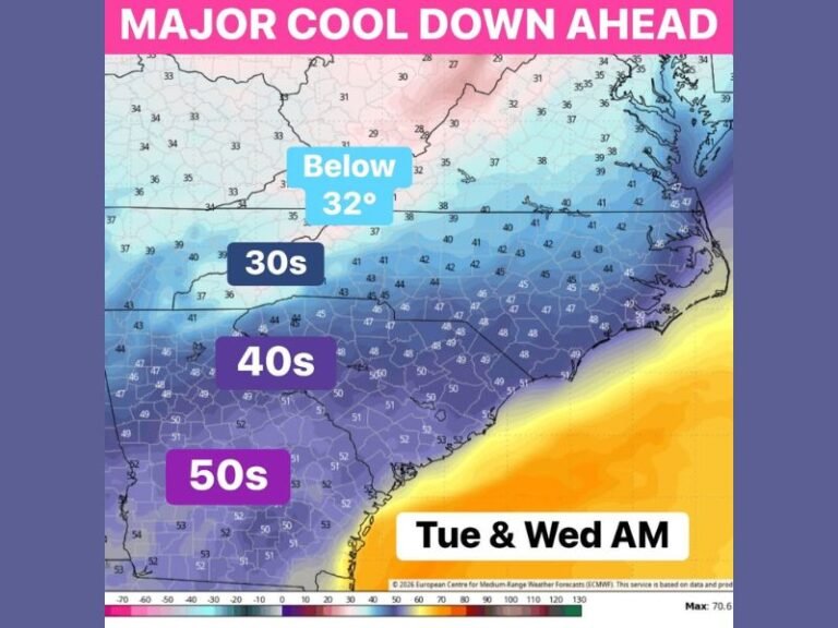
Nelsen also warned that the risk of regional flooding may rise under this pattern. “It’s been 30 years since our last major flood event,” he said, “and winters like these increase the odds — even if just slightly — that it could happen again.”
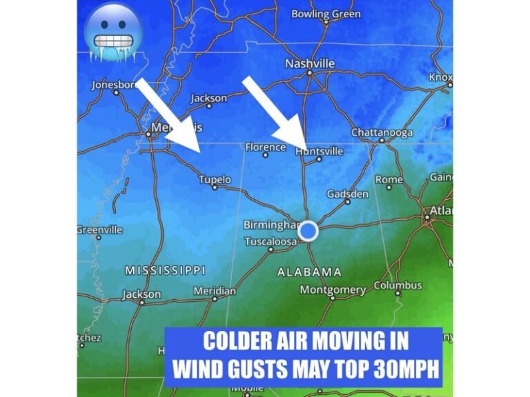
Meteorologists are also monitoring the potential for high-wind storms, noting that the Pacific Northwest is “overdue” for a major wind event. The last widespread regional windstorm struck in December 1995, with gusts topping 60 mph in Portland.
Snow Chances for the Pacific Northwest
Portland has seen measurable snow for 10 consecutive winters, a record streak for the city. While La Niña years often boost snowfall, warming ocean trends may soften those effects.
Still, the probability remains strong for at least one disruptive snow or ice event between December and February.
“The odds are good for a quick, high-impact storm like the one we saw last Valentine’s Day,” Nelsen added.
What It Means for the Rest of the Country
- Midwest and Great Lakes: Expect more lake-effect snow and colder-than-normal temperatures.
- Northeast: Variable; colder shots possible, but mixed with mild spells.
- South and Southeast: Likely warmer and drier, with reduced rainfall through midwinter.
While no two La Niña events are identical, forecasters say this winter’s setup could mirror weaker episodes seen in 2007–08 and 2011–12, producing short-lived cold snaps and intermittent snow events.
Residents are advised to prepare for shifting weather conditions and to stay updated through local National Weather Service alerts.
For detailed seasonal coverage and preparedness updates, visit SaludaStandard-Sentinel.com.