Heavy Rain Blossoms Over Already Saturated South Mississippi Tonight Raising Renewed Flash Flood Concerns Near Hattiesburg Laurel and Gulfport as Ground Reaches Capacity
HATTIESBURG, MS — A large area of heavy rain developed Friday night over South Mississippi communities already saturated and dealing with ongoing flooding issues, raising serious concerns that roads and creeks across the region could flood quickly with little advance warning as additional moisture pushes into ground that has very little capacity left to absorb it.
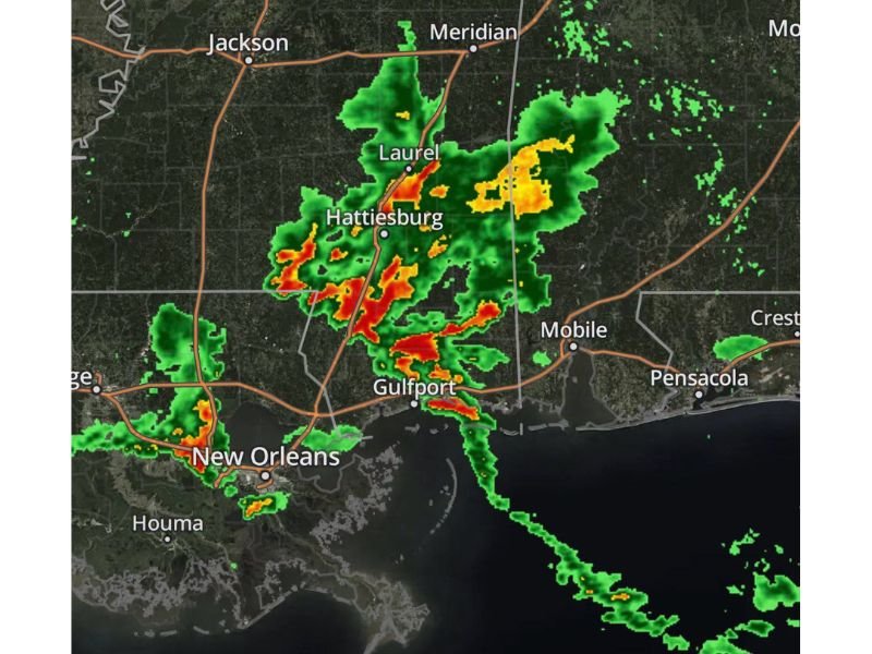
Radar Shows Intensifying Rain Across South Mississippi
Radar imagery Friday night showed an expansive area of heavy rainfall blossoming directly over Hattiesburg and Laurel, with embedded cores of intense rain rates indicated by red and orange returns stretching across the Pine Belt region. The heaviest rain was concentrated in a band extending from north of Hattiesburg southward toward the Gulf Coast.
Additional rain activity was also visible near Gulfport and along the coastal corridor, with lighter showers extending westward toward New Orleans and Houma, suggesting the moisture-rich pattern was affecting a broad swath of the central Gulf region simultaneously.
Saturated Ground Raises the Flooding Stakes
Unlike a typical summer shower, this event carries elevated risk because the ground across South Mississippi already has minimal capacity to absorb additional rainfall following previous flooding episodes. This means new rain is far more likely to run off rapidly, causing roads to flood quickly and creeks to rise fast, even in areas that experienced flooding earlier in the week.
Areas that already flooded once are considered particularly vulnerable to flooding again, often with little warning, as repeated heavy rain continues to fall on ground that cannot absorb it.
Nighttime Timing Increases the Danger
The overnight timing of this rainfall event adds another layer of risk, since flooding is considerably harder to see and react to after dark. Residents in flood-prone areas were urged to remain weather aware throughout the night and to have multiple methods available to receive warnings while sleeping.
Officials reiterated standard flood safety guidance, emphasizing that no one should ever drive through water covering a roadway, since floodwater depth and road conditions underneath cannot be reliably judged from a vehicle.
Communities Already Hit Hard Face Added Strain
Many families across South Mississippi have already been significantly impacted by recent flooding, making this additional round of heavy rain especially difficult for the region. Forecasters stressed that flood warnings issued throughout the night should be taken seriously given the compounding saturation already in place.
For continuing coverage of flooding threats and severe weather impacts across the United States, visit SaludaStandard-Sentinel.com.