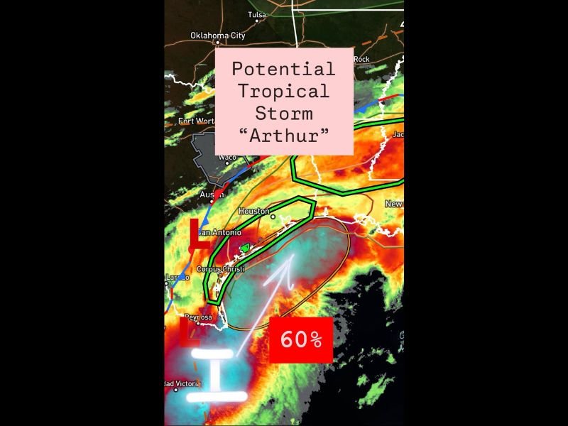
Potential Tropical Storm Arthur Threatening the Texas Gulf Coast With 60 Percent Formation Chance as Reconnaissance Heads Out Tuesday Morning
HOUSTON, TX — A low pressure trough breaking out into the western Gulf of Mexico carries a 60% formation probability Tuesday, June 16, with NHC data and model guidance suggesting a short-lived Tropical Storm Arthur could form by late Tuesday or Wednesday as the system moves into warm Gulf waters — bringing a rain and wind threat to the Texas Gulf Coast including Houston, Corpus Christi, and surrounding communities depending on the storm’s final track.
Current System Status
As of the 5 a.m. June 16 update, the low pressure trough was pushing out into the western Gulf, with reconnaissance aircraft scheduled to conduct a more comprehensive assessment of the system’s structure and organization through the day. The 60% formation probability reflects growing model and NHC confidence that a tropical circulation will develop as the system encounters the warm Gulf waters and more favorable atmospheric conditions offshore.
Higher-resolution model guidance is showing some disagreement on the exact track, creating uncertainty that will narrow significantly once reconnaissance data is processed. The Euro model keeps the system further offshore, bringing a few inches of rain inland while maintaining heavier rain bands along the coast. Higher-resolution guidance brings the system slightly closer to the Texas coastline, which would increase rainfall totals and wind impacts for coastal communities.
What to Watch For
If the system organizes and a more defined center develops, the primary concerns will shift to winds and rainfall on the eastern and northern sides of the circulation — the most active quadrants of any tropical system. Communities northeast of the eventual center, including the greater Houston area, would face the highest wind and rainfall risk depending on where Arthur makes its approach.
Track Uncertainty Remains Key
The difference between an offshore track and a closer coastal approach is the defining variable for Tuesday and Wednesday’s impacts across the Texas Gulf Coast. Communities from Corpus Christi through Houston and toward the Louisiana border should monitor updates closely through Tuesday as reconnaissance data and updated model runs provide significantly better clarity on the storm’s eventual path.
Residents along the Texas coast should prepare for heavy rainfall regardless of the track, as both scenarios bring meaningful rain to portions of the region.
For continuing coverage of Tropical Storm Arthur and Gulf Coast weather threats, visit SaludaStandard-Sentinel.com.