Flash Flood Risk and Tropical Wave Threaten Alabama Thursday and Friday With Isolated Tornado Possible as Flood Watches Stretch From Texas to Mississippi
BIRMINGHAM, AL — Alabama is entering a multi-day active weather pattern Tuesday, June 16, with a stalled front producing scattered showers and cooler temperatures today, flood watches posted from Texas to Mississippi, and a First Alert Weather Day declared for Thursday and Friday as a tropical wave crossing the northwest Gulf brings significant rainfall and an isolated tornado risk to the state.
Tuesday Conditions
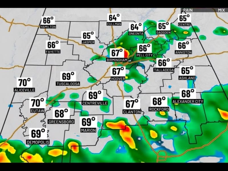
First Alert Weather radar at 7:00 a.m. Tuesday shows scattered shower activity already developing across central Alabama, with the most organized returns concentrated near Birmingham, Hoover, Pell City, and the Tuscaloosa corridor. Temperatures across the state are running in the mid to upper 60s region-wide at the morning hour, with Aliceville and Eutaw reaching 70°F as the warmest readings in the western counties.
A stalled front sitting over the state will keep scattered shower chances in the forecast through the day, with the greatest coverage expected across southern Alabama. Temperatures will stay in the 70s through most of Tuesday due to cloud cover, making for a humid but not oppressively hot day.
First Alert Days Thursday and Friday
The more significant weather arrives Thursday and Friday as a tropical wave expected to organize over the northwest Gulf crosses the region. Models show strong agreement on this system impacting Alabama through both days, generating significant rainfall and triggering a Flash Flood Risk designation for the period.
A low-end isolated tornado risk could also develop by late Thursday depending on the system’s exact track and strength. Hurricane Hunter aircraft are scheduled to fly today to gather additional data that will significantly sharpen the forecast for the Thursday-Friday window.
Gulf Coast Concerns
Along Alabama’s Gulf Coast, rain and storm chances remain elevated through the Juneteenth holiday and Saturday before decreasing toward more seasonal levels by Sunday. Rip current risk increases to high along Gulf Coast beaches Wednesday through Friday, posing a serious danger for swimmers during this period.
The Weekend Outlook
The tropical system exits quickly by the weekend, returning Alabama to a more typical summer pattern with isolated 20% popup afternoon storm chances and plenty of sunshine through Father’s Day Sunday.
For continuing coverage of Alabama weather and tropical threats across the United States, visit SaludaStandard-Sentinel.com.