SPC Level 4 Outbreak With EF3 Tornadoes Large Hail and Destructive Winds Threatening Illinois and Indiana Wednesday
CHICAGO, IL — The Storm Prediction Center has elevated Wednesday, June 17, to a Level 4 of 5 severe weather outbreak across portions of Illinois and Indiana, with EF-3 or stronger tornadoes possible within the intense core zone, very large hail, and destructive winds threatening the region as an abnormally strong jet streak combines with explosive summertime thermodynamics to produce one of the most alarming severe weather setups forecasters have seen this season.
Why This Setup Is Alarming
The driving force behind Wednesday’s elevated threat is an abnormally strong jet streak roaring into the Illinois and Indiana region, combining with potent summertime instability to create an environment capable of supporting multiple significant and intense tornadoes. The initiating boundary is expected to be a pre-frontal trough rather than a sweeping cold front — a critical distinction that will allow storms to remain dangerously discrete and fast-moving for a 3 to 4 hour window, more than enough time to produce many significant tornadoes.
The Risk Zone
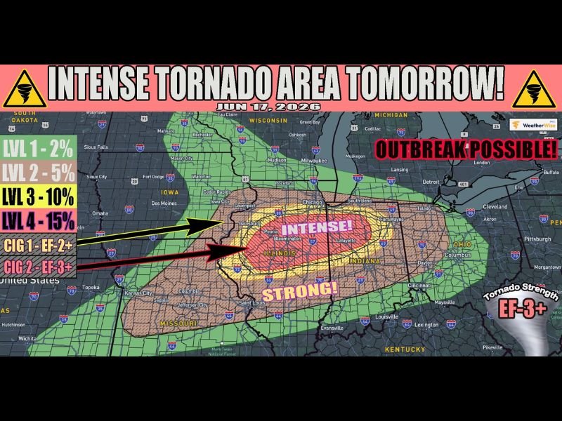
WeatherWise tornado probability data for June 17 places the highest risk corridor — Level 4 at 15% tornado probability with EF-3 or stronger potential — across central Illinois and into Indiana, labeled as the Intense zone on the outlook graphic. A surrounding Level 3 zone at 10% extends outward across a broader area labeled Strong, covering a large footprint from Iowa through Illinois, Indiana, and into Michigan. The outlook explicitly notes a tornado outbreak is possible.
All Hazards in Play
Beyond the intense tornado threat, very large hail and destructive winds are also on the table for Wednesday’s event. The combination of discrete supercells operating in an environment with explosive thermodynamics creates conditions where each storm can simultaneously produce all three major severe weather hazards.
The Early Morning Complication
An early morning round of storms Wednesday will need to be navigated first, as its placement of critical surface features will ultimately determine where the most intense supercells and tornadoes develop during the afternoon and evening window. Everyone within the Level 3 and Level 4 areas must be fully prepared regardless of the morning outcome.
For continuing coverage of this outbreak across Illinois and Indiana, visit SaludaStandard-Sentinel.com.