Significant Severe Weather Episode Targets Indiana Wednesday With 70 MPH Winds Strong Tornadoes and Large Hail Threatening Lafayette and Indianapolis
INDIANAPOLIS, IN — A significant severe weather episode is possible across Indiana on Wednesday, June 17, with all major hazards in play including damaging winds to 70 mph or greater, strong tornadoes, and large hail, primarily during a window from late afternoon to late evening across a broad swath of the state.
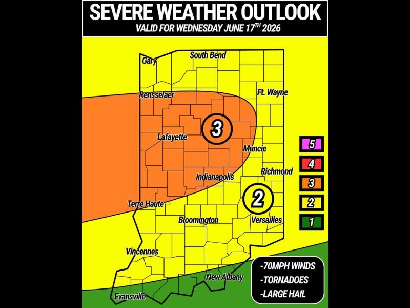
The Risk Levels Across Indiana
The severe weather outlook valid Wednesday, June 17, identifies a Level 3 of 5 risk zone encompassing Lafayette, Rensselaer, and the area extending toward Muncie in north-central Indiana. This represents the highest risk category on the current outlook, with the zone shaded orange covering communities from Gary and South Bend southward through Lafayette and toward Indianapolis.
A Level 2 of 5 risk zone covers a large portion of central and southern Indiana, including Indianapolis, Richmond, Versailles, Bloomington, and Vincennes. The southernmost portion of the state near Evansville and New Albany sits at a Level 1 risk, the lowest category shown on the outlook.
All Hazards Possible
Forecasters indicate all three major severe weather hazard types are possible Wednesday across the highlighted risk zones. Damaging winds reaching 70 mph or greater represent a significant threat capable of widespread tree damage, power outages, and structural impacts across affected communities. Strong tornadoes are also included in the hazard outlook, with some tornadoes potentially reaching significant intensity. Large hail rounds out the multi-hazard threat, capable of causing vehicle and property damage within the strongest storm cells.
Timing of the Event
The main timeframe for Wednesday’s severe weather is late afternoon through late evening, giving residents across the highest-risk corridor including Lafayette, Rensselaer, and the area surrounding Muncie a relatively defined window to prepare and remain weather aware.
Risk Levels Could Still Change
Forecasters caution that risk upgrades and shifts in the placement of the highest-threat zones remain possible as Wednesday approaches. Residents across Indiana, particularly within the Level 3 corridor, should continue monitoring updates closely.
What Residents Should Do
Anyone across central and northern Indiana should finalize shelter plans, secure loose outdoor items, and ensure weather alert systems are active ahead of Wednesday afternoon.
For continuing coverage of this developing severe weather outlook across the United States, visit SaludaStandard-Sentinel.com.