Highest Tornado Threat Targets Central and Northern Illinois Into Indiana Wednesday as Powerful Jet Stream Fuels Severe Storm Outbreak
CHICAGO, IL — An elevated severe weather threat is taking shape for Wednesday, June 17, across many of the same areas still recovering from Thursday’s outbreak, as a strong low pressure system surges into Wisconsin and combines with a powerful mid-level jet stream to produce the highest tornado threat across Central and Northern Illinois into Northern Indiana.
The Setup Driving Wednesday’s Threat
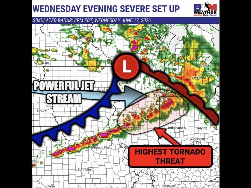
A strong low pressure system tracking into Wisconsin will interact with a powerful mid-level jet stream Wednesday, creating an environment highly favorable for organized severe weather. BAM Weather simulated radar valid 8 p.m. EDT Wednesday, June 17, shows the jet stream positioned across the Upper Midwest, with its dynamics directly fueling storm development across the highlighted threat corridor.
This combination of surface low pressure and jet stream energy is a classic setup for significant severe weather, particularly when it interacts with a region still recovering from a recent severe weather event, as additional moisture and instability often remain in place to support renewed storm development.
Where the Tornado Threat Is Highest
The simulated radar identifies Central and Northern Illinois extending into Northern Indiana as the zone carrying the highest tornado threat for Wednesday evening. This corridor includes Peoria, Springfield, and the area extending toward Chicago and the Illinois-Indiana border, with intense red, orange, and magenta reflectivity cores depicted across this region at the 8 p.m. timeframe.
A secondary line of intense storm activity is also shown stretching from Kansas through Missouri and into western Illinois, indicating storms may already be organized and moving toward the highest-threat zone as the evening progresses.
A Recovery Area Facing Renewed Risk
Forecasters specifically note that Wednesday’s setup poses an elevated threat for many of the same areas that experienced Thursday’s severe weather outbreak. Communities still dealing with damage or cleanup from the earlier event now face the prospect of renewed severe weather, including the potential for additional tornadoes within the highlighted corridor.
What Residents Should Do
Residents across Central and Northern Illinois and Northern Indiana should monitor forecasts closely as Wednesday approaches and ensure shelter plans are in place given the elevated tornado threat identified for the region.
For continuing coverage of this developing severe weather setup across the United States, visit SaludaStandard-Sentinel.com.