SPC Holds 15 Percent Severe Risk for Thursday Across Pennsylvania West Virginia and Virginia With Damaging Winds the Main Mid-Atlantic Threat
HARRISBURG, PA — The Storm Prediction Center has held a 15% severe weather probability for Thursday, June 18, across Pennsylvania, West Virginia, and Virginia, with damaging wind remaining the primary concern as storms ride through the mountains and into the Mid-Atlantic region, though forecasters note a key swing factor could shrink the risk area significantly depending on how the morning unfolds.
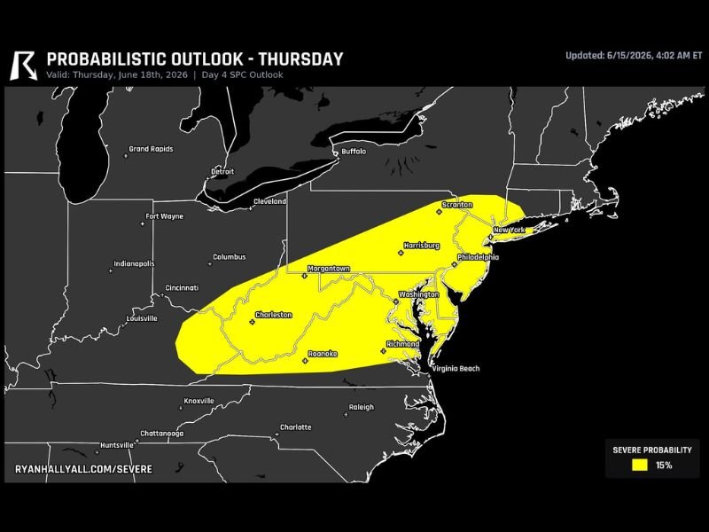
The Outlook Remains Unchanged
The Day 4 SPC probabilistic outlook updated June 15 at 4:02 a.m. ET continues to show a 15% severe probability zone stretching in an elongated corridor from Charleston, West Virginia, and Roanoke, Virginia, northeastward through Harrisburg, Scranton, and toward New York City and Philadelphia. This footprint has remained essentially unchanged from the previous day’s outlook, with forecasters indicating nothing significant has shifted in the overall pattern since yesterday’s assessment.
The risk zone encompasses Morgantown, Charleston, Roanoke, Harrisburg, Scranton, Washington, Richmond, Philadelphia, and New York — covering a heavily populated corridor across the Mid-Atlantic and into the southern tier of the Northeast.
Damaging Wind the Primary Threat
As storms develop and move through the Appalachian Mountains into the Mid-Atlantic Thursday, damaging wind remains the dominant hazard forecasters are tracking. This wind threat is associated with storms that organize and intensify as they descend from higher terrain into the lower elevations of the Mid-Atlantic, where increased instability can fuel further development.
The Key Swing Factor
Forecasters identified a critical variable that could dramatically alter Thursday’s outcome: whether morning clouds and rain moving in from the north consume the atmospheric fuel needed for afternoon storm development. If this scenario plays out, the severe weather potential across the highlighted zone would shrink quickly, significantly reducing both the coverage and intensity of Thursday’s storms.
Additional clarity on this swing factor is expected with updated model guidance the following day, which will help refine the placement and confidence level of Thursday’s severe weather threat.
What Residents Should Watch For
Residents across Pennsylvania, West Virginia, Virginia, and the broader Mid-Atlantic corridor should continue monitoring forecast updates as Thursday approaches, since the outcome remains heavily dependent on how the morning atmospheric setup evolves.
For continuing coverage of this developing severe weather outlook across the United States, visit SaludaStandard-Sentinel.com.