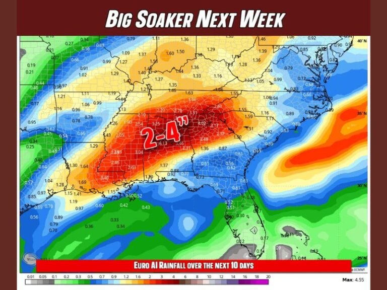
Heavy Rain and Flash Flood Watches Likely Across Alabama This Week as 3 to 6 Inches of Rainfall Threaten the State Through Friday Night
MONTGOMERY, AL — Alabama is bracing for a wet and potentially flood-prone stretch this week, with periods of rain expected today mainly across the southern half of the state, scattered to numerous showers and thunderstorms likely Tuesday and Wednesday as a stalled front sits over North Alabama, and the most significant rainfall arriving Thursday and Friday with totals of 3 to 6 inches likely statewide.
Today’s Rain Pattern
Radar early this morning showed rain already falling along the Alabama Gulf Coast, with the rest of the state remaining dry at daybreak. Periods of rain are likely throughout today, concentrated mainly over the southern half of Alabama, with mostly cloudy skies statewide and highs reaching the low to mid-80s.
Midweek Stalled Front
A stalled surface front remaining over North Alabama will bring scattered to numerous showers and thunderstorms Tuesday and Wednesday. Forecasters emphasize that rain will not fall continuously throughout either day, with a few peeks of sunshine expected to break through periodically across the affected areas.
Thursday and Friday: The Main Event
The most widespread and potentially dangerous rainfall arrives Thursday and Friday as another front drifts into the Deep South. Deep tropical moisture positioned ahead of this boundary will combine with the frontal lift to produce heavy rainfall at times. Flash flood watches will likely be required for much of Alabama during this period, with total rainfall amounts between now and Friday night reaching 3 to 6 inches across much of the state.
Forecast model precipitation imagery shows the heaviest accumulations concentrated across central and southern Alabama, with totals in some areas potentially exceeding 6 inches when combined with earlier-week rainfall.
Temperature Trends
Daily high temperatures through the week hold in the low to upper 80s, with Tuesday at 78°F before climbing back to 84 to 88°F by the weekend. Overnight lows remain in the mid to upper 60s to low 70s throughout the period, providing minimal relief from the humidity associated with the heavy rain setup.
Weekend Drying Trend
Drier air is expected to move into Alabama by the weekend, with only a few spotty showers remaining near the Gulf Coast as the pattern transitions away from the heavy rain threat.
For continuing coverage of Alabama rainfall and flooding threats across the United States, visit SaludaStandard-Sentinel.com.