EF2 Tornadoes Large Hail and 75 MPH Winds Targeting Iowa and Minnesota Wednesday With Cedar Rapids and Charles City Facing the Highest Tornado Risk in a Level 3 Setup
CEDAR RAPIDS, IA — A Level 3 tornado outbreak setup is taking shape for Wednesday, June 10, across Iowa and Minnesota, with the SPC Day 2 outlook placing Cedar Rapids, Charles City, and Decorah inside the highest tornado likelihood zone and forecasters warning that EF2 or stronger tornadoes are possible before a destructive squall line takes over with very large hail and winds exceeding 75 mph.
The Tornado Threat
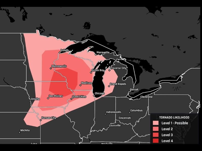
The single greatest tornado risk Wednesday is focused on eastern Iowa, with Cedar Rapids, Charles City, and Decorah identified as the bull’s-eye corridor for initial supercell development. Atmospheric conditions supporting this threat include 50 to 60 knots of wind shear and a strengthening low-level jet directed straight into eastern Iowa — a combination that meteorologists describe as capable of spinning up strong EF2 or greater tornadoes during the afternoon hours.
The tornado likelihood map updated June 9 at 4:47 a.m. ET places the core of eastern Iowa and southern Minnesota at Level 3 probability, with the broader risk zone extending across the Twin Cities, Madison, the Quad Cities corridor, and Des Moines at Level 2 and Level 1 outward through Omaha, Kansas City, and Chicago.
How the Storm Mode Evolves
Wednesday’s severe weather threat will unfold in two distinct phases. The afternoon hours carry the greatest tornado risk as discrete supercells develop ahead of the main line, taking advantage of available instability and strong wind shear before storm interactions begin to disrupt individual cell organization.
As the evening progresses, storms are expected to consolidate into a squall line — shifting the primary hazard from tornadoes toward very large hail and widespread damaging winds exceeding 75 mph across a broad corridor. This transition does not reduce the overall danger but changes the nature of the threat significantly for communities in the line’s path.
Broader Risk Zone
Beyond the Iowa and Minnesota core, the elevated tornado risk zone spans a large footprint covering Minneapolis, Madison, Green Bay, and the Chicago metro at lower probability tiers. Omaha, Kansas City, and Duluth all fall within the outer risk area and should not dismiss Wednesday’s potential.
Residents across all tiers of the outlook should finalize shelter plans Tuesday evening and keep all weather alert systems active through Wednesday night.
For continuing coverage of this developing tornado outbreak across Iowa and the Upper Midwest, visit SaludaStandard-Sentinel.com.
Author: Saluda Standard-Sentinel Team | Category: US News