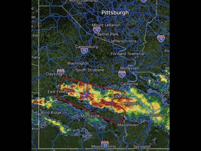
Tornado Warned Supercell Captured Between Kiowa and Limon Colorado Displaying Massive Wall Cloud and Powerful Rotating Structure Across the Eastern Plains
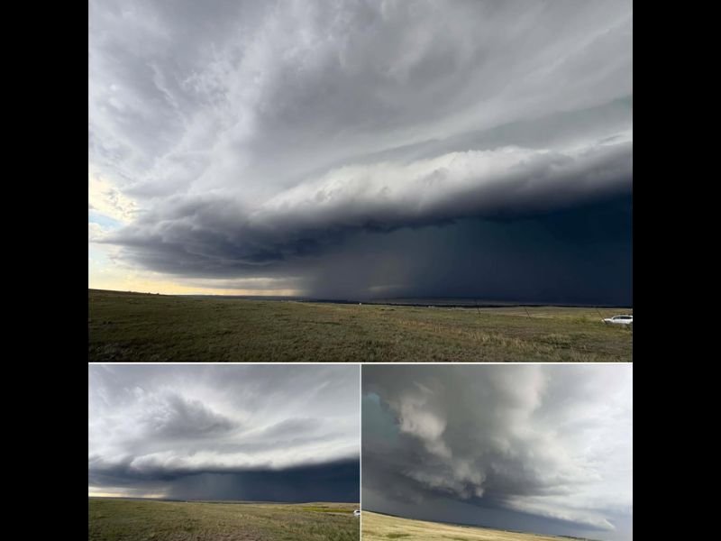
KIOWA, CO — A visually dramatic and meteorologically significant tornado-warned supercell thunderstorm was photographed actively churning between Kiowa and Limon across the Eastern Colorado Plains, displaying a massive, well-organized rotating wall cloud and classic supercell structure consistent with an imminent tornado threat at the time of observation.
What the Images Reveal
The photographs captured a textbook high-plains supercell at peak intensity. The dominant image shows a sweeping, layered storm structure stretching across the entire horizon, with a pronounced shelf and inflow bands curling dramatically upward into the storm’s rotating updraft base. The sky beneath the main updraft tower is darkened to near-black, indicating an extremely intense precipitation core and hail shaft directly beneath the storm’s most dangerous region.
The lower two photographs provide closer views of the wall cloud — the lowered, rotating cloud base that descends from the rain-free base of a supercell and is the direct precursor to tornado formation. The rotation visible in the cloud structure is tightly organized, confirming why a tornado warning was in effect at the time these images were taken.
Eastern Colorado Supercell Terrain
The Eastern Colorado Plains between Kiowa and Limon represent some of the most favorable terrain in the country for supercell development. The flat, open grassland allows storms to remain unobstructed and visible for dozens of miles in every direction, while the region’s position east of the Rockies provides ideal wind shear profiles that support long-track rotating updrafts.
Elbert County, where Kiowa is located, and Lincoln County surrounding Limon are sparsely populated agricultural communities where supercell storms can track for extended distances with limited warning infrastructure compared to more urban corridors.
The Tornado Warning Significance
A tornado warning issued for a storm of this visual caliber indicates that radar was detecting confirmed rotation at or near the surface in addition to the visible wall cloud structure apparent in the photographs. Residents within the warning polygon would have had limited time to seek shelter given the storm’s rapid development and intensification across the open plains.
Any vehicle caught in the open near a storm of this structure faces extreme danger from large hail, violent winds, and potential tornado touchdown.
For continuing coverage of tornado-warned storms and severe weather across Colorado and the United States, visit SaludaStandard-Sentinel.com.