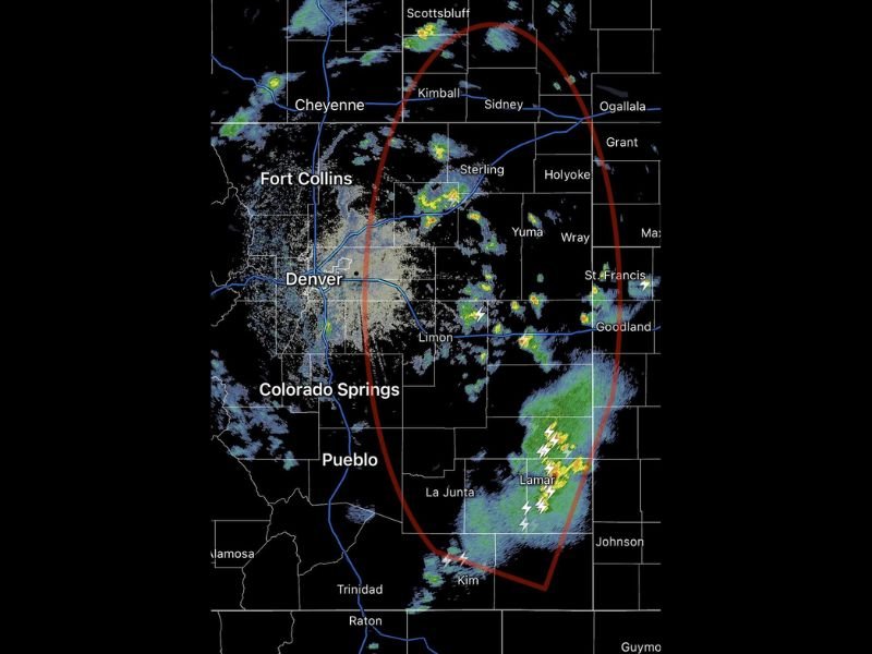
Scattered Showers and Thunderstorms Develop Across Colorado’s Eastern Plains Monday Afternoon With Active Storm Cluster Near Lamar and Outflow Boundaries
DENVER, CO — Scattered showers and thunderstorms are most active across Colorado’s eastern plains during Monday afternoon and evening, with a healthy convective complex rolling through Morgan County and a solid cluster of thunderstorms producing beneficial rainfall near Lamar in southeast Colorado.
Radar imagery shows the most organized storm activity concentrated along the eastern plains corridor, with additional outflow boundaries from earlier thunderstorms floating near the Front Range and acting as potential triggers for further shower and thunderstorm development over the next several hours before daytime heating diminishes.
Convective Complex Moves Through Morgan County as Lamar Cluster Produces Beneficial Rain
The most significant storm activity across Colorado’s eastern plains is focused in two primary areas, with the Morgan County convective complex tracking through the Sterling and surrounding corridor while an active and lightning producing thunderstorm cluster near Lamar drops genuinely beneficial rainfall across the drought stressed southeast Colorado landscape. The Lamar cluster is producing the heaviest radar returns visible across the eastern plains, with yellow and green reflectivity signatures indicating moderate to locally heavy rainfall across that portion of the state through the afternoon hours.
The Morgan County complex has already moved through its peak intensity phase, leaving behind outflow boundaries that could interact with the remaining daytime instability to trigger additional isolated storm development across the Front Range and adjacent plains communities before sunset.
Outflow Boundaries Near the Front Range Could Trigger Additional Storm Development
Several outflow boundaries from earlier thunderstorm activity are currently drifting across the greater Denver and Front Range corridor, creating potential triggers for new shower and storm development during the remaining hours of daytime heating. These mesoscale boundaries, while difficult for forecast models to precisely handle, represent the kind of smaller scale atmospheric feature that can initiate isolated but locally significant storm cells across communities from Fort Collins through Denver and Colorado Springs through the late afternoon hours.
Eastern Plains Storm Activity Expected to Continue Through the Evening Hours
Storm activity across Colorado’s eastern plains is expected to continue through the evening hours as the convective setup remains favorable for scattered thunderstorm development across the Limon, Lamar, and surrounding southeast Colorado communities. Residents across the eastern plains are encouraged to remain weather aware and monitor updated radar as additional storm development remains possible through the overnight period. For continuing coverage of storm forecasts across the United States, visit SaludaStandard-Sentinel.com.