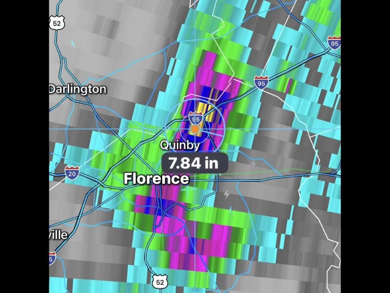
Nearly 8 Inches of Rain Inundates Florence and Quinby South Carolina in a Single Day as Slow Moving Storms Dump One of the Heaviest Rainfall Totals Seen in the Region So Far
FLORENCE, SC — Slow moving showers and storms dumped nearly 8 inches of rain across spots north of Florence, South Carolina on Saturday, with radar estimated totals reaching 7.84 inches near the Quinby corridor just north of Florence along Interstate 95. The extraordinary single day accumulation represents one of the highest rainfall totals recorded anywhere in the region so far in 2026, with the slow moving nature of the storm cells responsible for the extreme accumulation as repeated heavy rainfall trained over the same areas throughout the event.
Radar Confirms 7.84 Inch Rainfall Total Near Quinby Just North of Florence
Dual polarization radar estimated rainfall totals show a striking bull’s eye of extreme accumulation centered near Quinby, just north of Florence along the Interstate 95 corridor, where 7.84 inches of rainfall was recorded from Saturday’s slow moving storm activity. The radar imagery shows the most intense precipitation signatures in deep purple and magenta colors concentrated directly over the Quinby and north Florence zone, with the extraordinary color depth on the rainfall accumulation display confirming the historic nature of the single day totals recorded across this portion of South Carolina.
The slow forward speed of the storm cells responsible for this rainfall event is the primary meteorological driver of the extreme accumulation, as repeated heavy rain fell over the same limited geographic area throughout the day rather than progressing across a wider region.
Nearly 8 Inches Represents One of the Highest Single Day Totals of 2026 for the Region
For context, the nearly 8 inches of rainfall recorded near Florence on Saturday approaches or represents one of the highest single day precipitation totals observed anywhere across the region during the entire year of 2026 to date. Such an accumulation in a single day reflects an extraordinary atmospheric moisture scenario driven by slow storm motion over an already susceptible landscape, creating flash flooding conditions across low lying areas, drainage systems, and waterways throughout the Florence and Darlington County region.
The Interstate 95 corridor near Quinby and Florence, one of the major travel arteries along the East Coast, faced significant flooding concerns as the extreme rainfall accumulated across the immediate area throughout the event.
Sunday Brings More Rain Chances Inland as Grand Strand Chances Decrease by Afternoon
Looking ahead to Sunday, scattered showers and storms are expected near the coast during the morning hours before rain chances along the Grand Strand decrease through the afternoon. Inland areas face an increasing chance of showers and storms with heavy rain likely through the Sunday afternoon and evening period, extending the wet and active weather pattern across the Pee Dee and broader inland South Carolina region into the new day.
Residents across Florence, Darlington, and surrounding communities are urged to monitor flood conditions closely and avoid flooded roadways through Sunday as additional rainfall falls on already saturated ground.
For continuing coverage of extreme rainfall events and flood threats across the United States, visit SaludaStandard-Sentinel.com.