Strong Storms Ahead for Upstate South Carolina and Western North Carolina Sunday With Activity Escalating From Isolated Morning Showers to Heavy Evening Rain and Storms by 9 PM
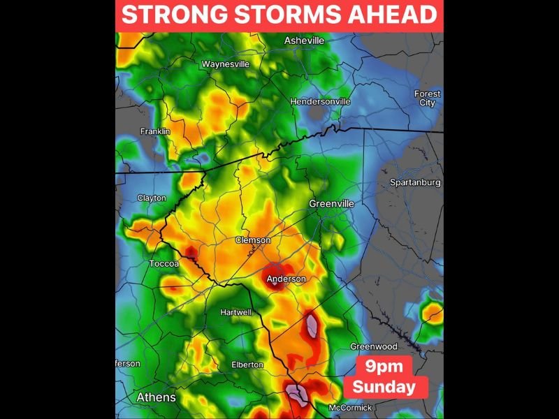
GREENVILLE, SC — A progressive and escalating storm pattern is developing across Upstate South Carolina and the western North Carolina mountains for Sunday, beginning with isolated showers in the morning before transitioning to scattered afternoon storms and ultimately heavy evening rain and strong storms by 9:00 PM. Forecast radar imagery valid for 9:00 PM Sunday shows intense orange and red reflectivity returns concentrated across a broad zone stretching from the Asheville and Hendersonville corridor southward through Greenville, Clemson, Anderson, and into the Greenwood and McCormick areas of South Carolina.
Sunday Storm Pattern Escalates Through Three Distinct Phases From Morning to Night
The Sunday weather pattern across Upstate South Carolina and western North Carolina follows a clear three phase progression, beginning with isolated showers during the morning hours before coverage and intensity increase through the afternoon into scattered storm activity. The most significant and impactful phase arrives during the evening hours, with heavy rain and strong storms expected to develop across the region by 9:00 PM as the atmospheric setup reaches its peak instability window through the late Sunday evening hours.
This progressive escalation throughout the day requires residents across the affected region to remain weather aware through the entire Sunday period rather than only during the morning or afternoon hours.
Forecast Radar at 9 PM Shows Intense Storm Activity From Asheville Through Anderson
The 9:00 PM Sunday forecast radar image shows a striking concentration of intense storm returns covering a large swath of the Upstate South Carolina and western North Carolina region. Orange and red reflectivity returns blanket communities including Waynesville, Franklin, Hendersonville, Asheville, Greenville, Clemson, Anderson, Hartwell, Toccoa, and Elberton, with the most extreme deep red and pink signatures concentrated near the Anderson, Greenwood, and McCormick corridors where the heaviest evening rainfall is anticipated.
The geographic coverage of the 9:00 PM storm footprint across both the South Carolina Upstate and the North Carolina mountain region reflects the broad reach of Sunday’s evening storm system across a highly populated and topographically diverse corridor.
Greenwood and McCormick Areas Face Additional Heavy Rain on Already Saturated Ground
Of particular concern for Sunday evening’s heavy rain and storm activity is the Greenwood and McCormick corridor, which has already received extraordinary rainfall totals in recent days from prior storm events. Additional heavy evening rainfall falling on already saturated soils across these communities dramatically elevates the flash flooding risk, as runoff from new rainfall has nowhere to go when the ground is already at or near full saturation capacity.
Residents across all communities within the Sunday evening storm zone are urged to monitor updated flash flood and severe weather information closely throughout the day and take shelter as the heavy evening storm activity arrives after 9:00 PM.
For continuing coverage of storm forecasts and flood threats across the United States, visit SaludaStandard-Sentinel.com.