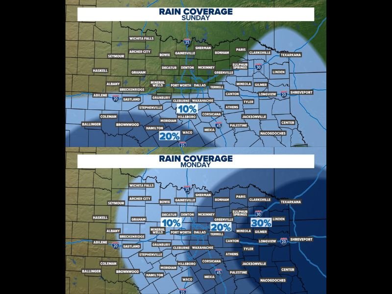
Spotty Showers and Storms Possible Across North and Central Texas Sunday and Monday With Low Rain Coverage of 10 to 30 Percent and Neither Day Expected to Be a Washout
DALLAS, TX — Rain coverage across North and Central Texas will remain on the lower side through both Sunday and Monday, with spotty showers and storms possible during the afternoon and early evening hours on each day without either day becoming a widespread washout for the region. Sunday’s rain coverage map shows 10 percent probability across the Dallas and Fort Worth corridor expanding to 20 percent across the Waco and Central Texas zone, while Monday’s coverage increases slightly with 10 percent across the western areas, 20 percent near the Metroplex, and 30 percent across the east Texas corridor near Linden and Sulphur Springs.
Sunday Brings Low 10 to 20 Percent Rain Coverage Mainly in the Afternoon Hours
Sunday’s rain coverage across North and Central Texas is limited and spotty in nature, with the highest probability of 20 percent concentrated across the Waco and surrounding Central Texas communities while the Dallas and Fort Worth Metroplex sits at 10 percent coverage for the day. The best timing for any shower or storm development on Sunday will be during the afternoon and early evening hours as daytime heating provides the limited instability available to trigger isolated convective development across the region.
Communities across Hillsboro, Corsicana, Meridian, and the broader Central Texas zone fall within the 20 percent coverage area Sunday, while the Metroplex and areas further north including Denton, McKinney, and Sherman carry the lower 10 percent probability through the same afternoon window.
Monday Coverage Increases Slightly With 30 Percent Possible in East Texas
Monday brings a modest increase in rain coverage compared to Sunday, with the eastern portions of the North Texas region seeing the highest individual day probability at 30 percent near the Linden and Sulphur Springs corridor. The Dallas and Fort Worth Metroplex tracks at 20 percent coverage on Monday, while western communities including Mineral Wells, Decatur, and Breckenridge remain at the lower 10 percent range through the Memorial Day holiday afternoon hours.
The slight eastward shift in the highest rain probability on Monday compared to Sunday reflects the gradual movement of available atmospheric moisture across the region through the holiday weekend period.
Neither Sunday nor Monday Expected to Wash Out Outdoor Holiday Plans
The most reassuring aspect of the Sunday and Monday rain coverage forecast for North and Central Texas is that neither day carries sufficient coverage or storm intensity to constitute a widespread washout for residents with Memorial Day weekend outdoor plans. The spotty and isolated nature of any shower or storm development on both days means the majority of communities across the region will remain dry through most of the afternoon and evening hours.
Residents across North and Central Texas are encouraged to keep an eye on afternoon radar trends and be prepared for a brief storm delay possibility during peak afternoon heating hours on both days.
For continuing coverage of holiday weekend weather forecasts across the United States, visit SaludaStandard-Sentinel.com.