Heavy Rain and Flooding Drench Southeast Louisiana as Baton Rouge and New Orleans Take a Direct Hit From an Intense Gulf Coast Storm System
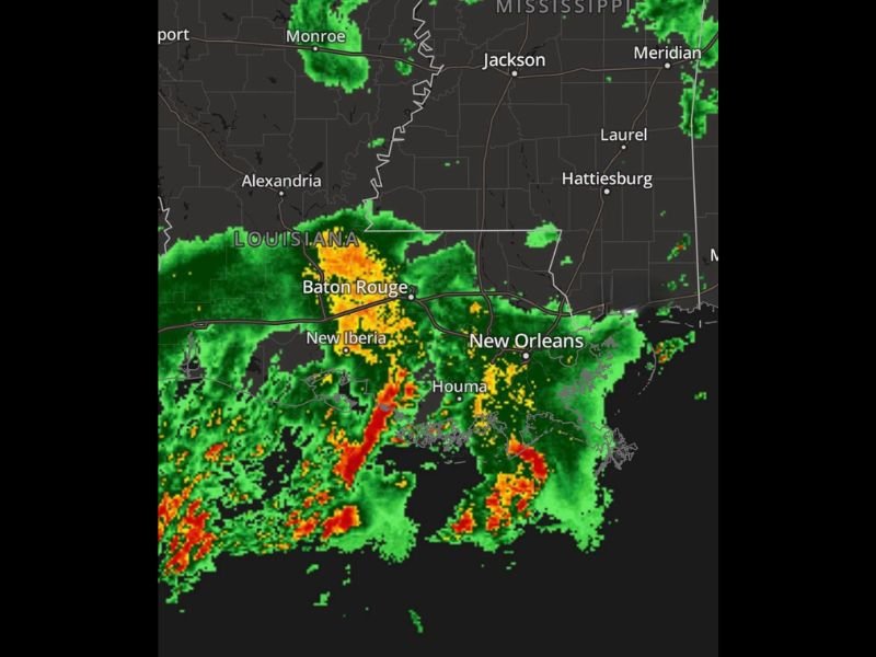
NEW ORLEANS, LA — Southeast Louisiana is being hammered by an intense and widespread heavy rain event as a powerful Gulf Coast storm system targets Baton Rouge, New Orleans, Houma, and surrounding communities with extreme rainfall and flooding conditions. Radar imagery shows deep red and orange reflectivity returns concentrated across a broad corridor stretching from Baton Rouge southward through New Iberia, Houma, and into the New Orleans metropolitan area, with the most intense rainfall cores producing significant street flooding and urban inundation across the heavily populated southeast Louisiana region.
Baton Rouge Takes a Direct Hit as Intense Rainfall Core Targets the Metro Area
The heaviest radar returns on the current imagery are concentrated directly over and around the Baton Rouge metropolitan area, with deep red and orange reflectivity signatures indicating extreme rainfall rates falling across the city and surrounding communities. The intense rainfall core positioned over Baton Rouge is producing the kind of rapid accumulation rates capable of overwhelming urban drainage infrastructure and causing widespread street flooding across low lying neighborhoods, underpasses, and roadways throughout the metro area.
The storm system’s positioning directly over Baton Rouge reflects the focused and concentrated nature of the heaviest rainfall within the broader southeast Louisiana storm complex, making this one of the more significant urban flooding events to impact the capital city region in recent memory.
New Orleans and Houma Also Under Significant Rainfall and Flooding Threat
Beyond Baton Rouge, the storm system extends southeastward through Houma and into the New Orleans metropolitan area, placing both communities under significant rainfall and flooding concerns as the Gulf Coast storm complex continues its impact across southeast Louisiana. The radar returns across the New Orleans corridor show active and ongoing heavy rainfall cells tracking through the area, with the city’s well documented vulnerability to heavy rainfall and drainage challenges making this storm system a particularly serious event for urban flood management across the region.
Houma and surrounding Terrebonne Parish communities situated between Baton Rouge and New Orleans also fall within the active heavy rainfall zone, facing their own localized flooding concerns as the storm system tracks through the south Louisiana coastal plain.
Southeast Louisiana Residents Urged to Avoid Flooded Streets and Stay Indoors
All residents across southeast Louisiana, and particularly those in Baton Rouge, New Orleans, Houma, and New Iberia, are strongly urged to avoid driving through flooded streets and to remain indoors until the heavy rainfall event passes and water levels recede across the region. The Turn Around Don’t Drown message is critically important for all motorists across the affected southeast Louisiana corridor as this intense Gulf Coast storm system continues delivering extreme rainfall to an already flood vulnerable region.
For continuing coverage of flooding and heavy rainfall events across the United States, visit SaludaStandard-Sentinel.com.