Severe Thunderstorm Warning Issued for Fort Bend, Brazoria, Galveston, and Harris Counties in Texas With 50 MPH Winds and One Inch Hail Threatening Sugar Land, Missouri City, and Pearland Until 12:30 AM
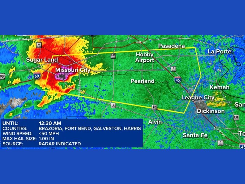
HOUSTON, TX — A Severe Thunderstorm Warning was issued for Fort Bend, Brazoria, Galveston, and Harris counties in Texas until 12:30 AM May 1, as radar-indicated severe thunderstorms pushed through the greater Houston metro area during the early Friday morning hours, bringing wind speeds under 50 miles per hour and hail up to one inch in diameter across a wide stretch of the region.
Alert Radar imagery captured at 12:03 AM Friday showed intense storm cells concentrated across the Sugar Land and Missouri City corridor, with deep red and purple reflectivity returns indicating the heaviest precipitation core positioned southwest of downtown Houston and tracking eastward through the warned county areas.
Four County Warning Zone Covers Houston Metro Corridor
The Severe Thunderstorm Warning encompassed four of the most densely populated counties in the greater Houston metropolitan area, placing a massive combined population base under the active warning through the 12:30 AM expiration. Fort Bend County communities including Sugar Land and Missouri City sat within the most intense portion of the storm activity at the time of the warning issuance, with the storm complex pushing eastward toward Harris County and the broader Houston metro through the overnight hours.
The warning polygon outlined in yellow on radar stretched eastward from the Sugar Land and Missouri City area through Pearland, Hobby Airport, Pasadena, League City, and Dickinson, reflecting the significant geographic reach of the severe thunderstorm complex across the southeastern Houston corridor.
50 MPH Winds and One Inch Hail Pose Property Threat
The primary hazards associated with the severe thunderstorm warning included wind speeds approaching 50 miles per hour and hail measuring up to one inch in diameter. Winds of this magnitude pose a threat to unsecured outdoor property, tree limbs, and power lines across the warned communities, while one inch hail carries the potential for vehicle and property damage across the affected Houston metro counties.
Radar indication served as the source for the warning, with storm characteristics consistent with severe thunderstorm criteria detected across the Fort Bend and Harris County corridor at the time of issuance at 12:03 AM Friday.
Residents Urged to Seek Immediate Shelter
With the Severe Thunderstorm Warning active across Fort Bend, Brazoria, Galveston, and Harris counties, residents across Sugar Land, Missouri City, Pearland, Pasadena, League City, Dickinson, Alvin, Kemah, La Porte, and surrounding communities were urged to seek shelter immediately and remain indoors until the warning expired at 12:30 AM. Staying away from windows and securing any loose outdoor items represented the recommended immediate actions for residents across the four-county Houston metro warning area.
For continuing coverage of severe weather events and critical storm analysis across the United States, visit SaludaStandard-Sentinel.com.